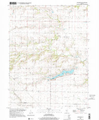
1998 Map of Greenbush
USGS Topo · Published 2001About this map
Greenbush serves as the focal point of this western Illinois landscape, where the township structure of the prairie meets a complex system of wooded draws and drainage basins. The area is defined by the headwaters and tributaries of several prominent waterways, including Swan Creek, Negro Creek, and the southern reach of the East Fork La Moine River. These stream valleys contrast with the level agricultural sections of Roseville and Berwick to the north, creating a varied terrain that dictated early settlement patterns. For researchers, the map identifies several distinct family and community burial sites, such as Bond Cem, McMahill Cem, and Larkins Cem, which provide specific location data for local genealogy. The central corridor is anchored by Swan Lake and the nearby Townhall, illustrating the persistent community nodes that have remained as the region maintained its rural character into the late twentieth century.
Find a feature on this map
23 named features on this map. Tap any name to fly to it.
Don’t see what you’re looking for? This feature index may not catch every label — zoom into the map to look around manually.
Map Details
Editions of this 1998 Greenbush Map
This is the sole edition of this map. No revisions or reprints were ever made.
Other maps of this area

1915 · Avon
USGS Topo · 1:62,500

1916 · Good Hope
USGS Topo · 1:62,500

1918 · Good Hope
USGS Topo · 1:62,500

1921 · Monmouth
USGS Topo · 1:62,500

1923 · Monmouth
USGS Topo · 1:62,500

1925 · Galesburg
USGS Topo · 1:62,500

1927 · Galesburg
USGS Topo · 1:62,500

1944 · Avon
USGS Topo · 1:62,500

1958 · Burlington
USGS Topo · 1:250,000

1961 · Burlington
USGS Topo · 1:250,000