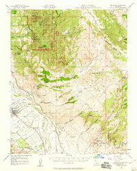
1957 Map of Greenfield
USGS Topo · Published 1959About this map
Pinnacles National Monument dominates the northwestern portion of this 1957 survey, highlighting peaks like North Chalone Peak and Mt Defiance. The landscape transitions from these jagged rock formations into the agricultural heart of the Salinas Valley, where the Salinas River and Arroyo Seco converge. The settlement of Greenfield is shown in its mid-century layout, surrounded by named Mexican land grants including the Posa de los Ositos and Soberanes grants, which reflect the area's deep pastoral heritage.
Find a feature on this map
58 named features on this map. Tap any name to fly to it.
Don’t see what you’re looking for? This feature index may not catch every label — zoom into the map to look around manually.
Map Details
Editions of this 1957 Greenfield Map
3 editions found
Other maps of this area

1912 · Metz
USGS Topo · 1:31,680

1913 · Panoche
USGS Topo · 1:125,000

1915 · Soledad
USGS Topo · 1:62,500

1915 · Priest Valley
USGS Topo · 1:125,000

1919 · King City
USGS Topo · 1:62,500

1919 · San Benito
USGS Topo · 1:62,500

1919 · Junipero Serra
USGS Topo · 1:62,500

1921 · Gonzales
USGS Topo · 1:62,500

1921 · Metz
USGS Topo · 1:62,500

1931 · San Benito
USGS Topo · 1:62,500