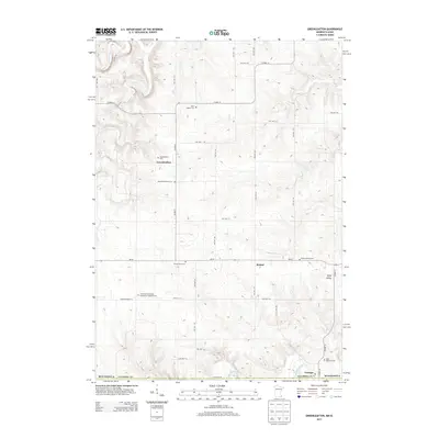
2013 Map of Greenleafton
USGS Topo · Published 2013About this map
The small settlements of Greenleafton and Bristol anchor this portion of Fillmore County along the Minnesota-Iowa border. The landscape is defined by the winding course of Canfield Cr and Willow Cr, which eventually give way to the Upper Iowa River at the southern edge of the sheet. This area shows a deep historical footprint through its numerous community burial grounds, including the Saetersdal Norwegian Evangelical Lutheran Cem and Bristol Grove Cem. The presence of both the Greenleafton Cem and an Old Greenleafton Cem suggests a shift in the local center of gravity or church affiliation over generations. To the southeast, the village of Granger sits directly against the state line, where the road network transitions into the Iowa landscape. The topography transitions through Daisy Valley and across several local ridges, which are navigated by a dense grid of township roads such as TWP HWY 312 and Co HWY-9.
Find a feature on this map
44 named features on this map. Tap any name to fly to it.
Don’t see what you’re looking for? This feature index may not catch every label — zoom into the map to look around manually.
Map Details
Editions of this 2013 Greenleafton Map
This is the sole edition of this map. No revisions or reprints were ever made.
Other maps of this area

1954 · Mason City
USGS Topo · 1:250,000

1957 · Mason City
USGS Topo · 1:250,000

1958 · Mason City
USGS Topo · 1:250,000

1965 · Greenleafton
USGS Topo · 1:24,000

1965 · Harmony
USGS Topo · 1:24,000

1965 · Wykoff
USGS Topo · 1:24,000

1965 · Fountain
USGS Topo · 1:24,000

1965 · Cherry Grove
USGS Topo · 1:24,000
1965 · Preston
USGS Topo · 1:24,000

1981 · Cresco NW
USGS Topo · 1:24,000