
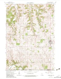
1965 Map of Harmony
USGS Topo · Published 1966About this map
The town of Harmony serves as a focal point in this mid-1960s survey of the Minnesota-Iowa border region, where the Chicago Milwaukee St Paul and Pacific railroad cuts a diagonal path through the landscape. The northern portion of the sheet is dominated by the Minnesota Memorial Hardwood State Forest, a protected area that reflects the rugged transition from timbered uplands to agricultural flats. For local historians, the map preserves the locations of several small community centers like Hutton and Big Spring, alongside numerous rural burial grounds including Rice Cem and Greenfield Cem.
Find a feature on this map
30 named features on this map. Tap any name to fly to it.
Don’t see what you’re looking for? This feature index may not catch every label — zoom into the map to look around manually.
Map Details
Editions of this 1965 Harmony Map
2 editions found
Other maps of this area

1906 · Decorah
USGS Topo · 1:125,000

1954 · Mason City
USGS Topo · 1:250,000

1957 · Mason City
USGS Topo · 1:250,000

1958 · Mason City
USGS Topo · 1:250,000

1958 · La Crosse
USGS Topo · 1:250,000

1961 · La Crosse
USGS Topo · 1:250,000

1965 · La Crosse
USGS Topo · 1:250,000

1965 · Greenleafton
USGS Topo · 1:24,000

1965 · Canton
USGS Topo · 1:24,000
1965 · Lanesboro
USGS Topo · 1:24,000