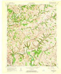
1961 Map of Greensburg
USGS Topo · Published 1962About this map
The Green River winds through the heart of this central Kentucky landscape, carving deep bends and creating a series of named river holes including Spillmans Hole, Boom Hole, and White Springs Hole. In the early 1960s, the region around Greensburg was characterized by a distinct agrarian and industrial balance, where the O+L Field and numerous gas wells shared the land with small rural communities and family farms. Significant river features such as Marcum Island and Snaps Island punctuate the waterway, while the surrounding hills are dotted with a dense network of country churches and cemeteries. Family names are deeply embedded in the local geography, seen in sites like Cowherd Cem, Taylor Cem, and Blakeman Cem. Small hamlets like Black Gnat and Bengal serve as local anchors, connected by a terrain of ridges and creek valleys such as Big Pitman Creek.
Find a feature on this map
50 named features on this map. Tap any name to fly to it.
Don’t see what you’re looking for? This feature index may not catch every label — zoom into the map to look around manually.
Map Details
Editions of this 1961 Greensburg Map
2 editions found
Other maps of this area

1953 · Campbellsville
USGS Topo · 1:24,000

1953 · Saloma
USGS Topo · 1:24,000

1953 · Hibernia
USGS Topo · 1:24,000

1953 · Summersville
USGS Topo · 1:24,000

1953 · Exie
USGS Topo · 1:24,000

1953 · Gresham
USGS Topo · 1:24,000

1953 · Spurlington
USGS Topo · 1:24,000

1953 · Cane Valley
USGS Topo · 1:24,000

1954 · Greensburg
USGS Topo · 1:24,000

1957 · Winchester
USGS Topo · 1:250,000