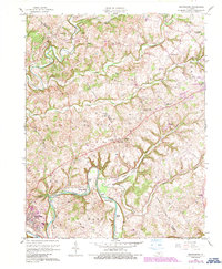
1961 Map of Greensburg
USGS Topo · Published 1987About this map
Green River winds through the heart of this central Kentucky landscape, carving deep bends and creating distinctive river features like Cox Bend and Spillmans Hole. The topography is defined by the sharp transition between the river lowlands and the higher elevations of Marshall Ridge, with numerous Gas Wells scattered throughout the northern sections, particularly within the Big South Field. This era of the mid-twentieth century shows a dispersed rural settlement pattern anchored by small communities such as Black Gnat and Bengal. Local history and family genealogy are well-represented by numerous country churches and cemeteries, including Beech Grove Ch and Parrott Cem. The boundary between Taylor and Green counties bisects the quadrangle, illustrating the connectivity between the regional hub at Greensburg and the neighboring outskirts of Campbellsville.
Find a feature on this map
44 named features on this map. Tap any name to fly to it.
Don’t see what you’re looking for? This feature index may not catch every label — zoom into the map to look around manually.
Map Details
Editions of this 1961 Greensburg Map
2 editions found
Other maps of this area

1953 · Campbellsville
USGS Topo · 1:24,000

1953 · Saloma
USGS Topo · 1:24,000

1953 · Hibernia
USGS Topo · 1:24,000

1953 · Summersville
USGS Topo · 1:24,000

1953 · Exie
USGS Topo · 1:24,000

1953 · Gresham
USGS Topo · 1:24,000

1953 · Spurlington
USGS Topo · 1:24,000

1953 · Cane Valley
USGS Topo · 1:24,000

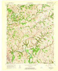
1954 · Greensburg
USGS Topo · 1:24,000

1957 · Winchester
USGS Topo · 1:250,000