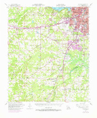
1955 Map of Greenwood
USGS Topo · Published 1970About this map
Shreveport expands westward into the piney woods and bayous of western Caddo Parish in this mid-century survey, revised with late-1960s urban data. The landscape is defined by the massive Cross Lake to the north and the sprawling Wallace Lake to the southeast, with the Texas and Pacific and Kansas City Southern railroads anchoring the commercial corridor through Greenwood and Keithville. This era reveals a transition from rural agricultural clusters to a modern transportation hub, evidenced by the development of the Greater Shreveport Municipal Airport. Local history is preserved through dozens of country schoolhouses and churches like Galilee Ch and White Hall Sch. Notable institutions of the day are also documented, including the Caddo Parish Penal Farm and The Pines Sanatorium, alongside numerous family burial grounds such as Page Cem and Pollard Cem.
Find a feature on this map
110 named features on this map. Tap any name to fly to it.
Don’t see what you’re looking for? This feature index may not catch every label — zoom into the map to look around manually.
Map Details
Editions of this 1955 Greenwood Map
2 editions found

Other maps of this area

1932 · Bossier SW
USGS Topo · 1:31,680

1932 · Shreveport SE
USGS Topo · 1:31,680

1941 · Forbing
USGS Topo · 1:31,680

1943 · Waskom
USGS Topo · 1:62,500

1944 · Caddo Lake
USGS Topo · 1:62,500

1945 · Grand Cane
USGS Topo · 1:62,500

1945 · Waskom
USGS Topo · 1:62,500

1945 · Greenwood
USGS Topo · 1:62,500

1945 · Socagee Bayou
USGS Topo · 1:62,500

1945 · Mansfield
USGS Topo · 1:62,500