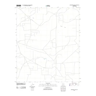
2010 Map of Greenwood Lake
USGS Topo · Published 2010About this map
Querecho Plains dominate this landscape in Lea County, New Mexico, where the high desert terrain is defined by a sparse network of rural transit and natural basins. The namesake Greenwood Lake is a prominent hydrologic feature in an otherwise arid expanse, serving as a focal point for the surrounding topography. The layout of the land is largely shaped by a grid of county thoroughfares, including County Rd 249, Westall Rd, and County Hwy 222. This 2010 survey reflects the modern infrastructure of the region, illustrating how local roads bridge the distances across the open plains. The intersection of County Rd 248 and other local routes indicates the primary corridors for ranching or industrial access typical of this portion of the Llano Estacado.
Find a feature on this map
7 named features on this map. Tap any name to fly to it.
Don’t see what you’re looking for? This feature index may not catch every label — zoom into the map to look around manually.
Map Details
Editions of this 2010 Greenwood Lake Map
This is the sole edition of this map. No revisions or reprints were ever made.
Other maps of this area

1942 · Clayton Basin
USGS Topo · 1:62,500

1943 · Clayton Basin
USGS Topo · 1:62,500

1954 · Hobbs
USGS Topo · 1:250,000

1958 · Hobbs
USGS Topo · 1:250,000

1962 · Buckeye
USGS Topo · 1:62,500

1963 · Laguna Gatuna
USGS Topo · 1:62,500

1963 · Maljamar
USGS Topo · 1:62,500

1984 · Laguna Gatuna NW
USGS Topo · 1:24,000
1984 · Laguna Gatuna
USGS Topo · 1:24,000
1985 · Tower Hill North
USGS Topo · 1:24,000