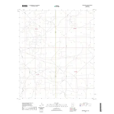
2020 Map of Greenwood Lake
USGS Topo · Published 2020About this map
Greenwood Lake sits at the heart of this high-desert landscape on the boundary of Eddy and Lea Counties. The terrain is defined by a network of local roads and unimproved trails that traverse the township and range lines, reflecting the modern management of this remote corner of New Mexico. Routes such as Westall Rd, Shugart Rd, and Lusk Rd provide access to the area, while the Dunes Access area in the southwest corner indicates the undulating sandy topography typical of the region. This 2020 survey documents a workspace of energy infrastructure and rural land management, where the straight lines of county roads like Co Rd 249 and Co Rd 126 contrast with the natural depression of the lake bed and the surrounding dunes.
Find a feature on this map
14 named features on this map. Tap any name to fly to it.
Don’t see what you’re looking for? This feature index may not catch every label — zoom into the map to look around manually.
Map Details
Editions of this 2020 Greenwood Lake Map
This is the sole edition of this map. No revisions or reprints were ever made.
Other maps of this area

1942 · Clayton Basin
USGS Topo · 1:62,500

1943 · Clayton Basin
USGS Topo · 1:62,500

1954 · Hobbs
USGS Topo · 1:250,000

1958 · Hobbs
USGS Topo · 1:250,000

1962 · Buckeye
USGS Topo · 1:62,500

1963 · Laguna Gatuna
USGS Topo · 1:62,500

1963 · Maljamar
USGS Topo · 1:62,500

1984 · Laguna Gatuna NW
USGS Topo · 1:24,000
1984 · Laguna Gatuna
USGS Topo · 1:24,000
1985 · Tower Hill North
USGS Topo · 1:24,000