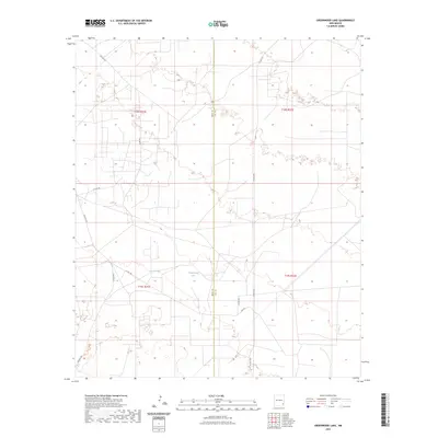
2023 Map of Greenwood Lake
USGS Topo · Published 2023About this map
Greenwood Lake serves as a primary geographic anchor in this section of the Chihuahuan Desert, situated along the border of Eddy and Lea Counties. The landscape is defined by a dense network of oil and gas access roads, such as Shugart Rd and Westall Rd, which crisscross the grid of the Public Land Survey System. These roads trace the industrial development of the Permian Basin, connecting remote well sites across Township 18 South, Range 31 East and neighboring tracts. The topography is marked by numerous depressions and flats, characteristic of the region's karstic and aeolian surface. Modern infrastructure like Lusk Rd and Co Rd 126 provides the primary transit corridors through this arid terrain, where historical land boundaries meet contemporary energy extraction.
Find a feature on this map
13 named features on this map. Tap any name to fly to it.
Don’t see what you’re looking for? This feature index may not catch every label — zoom into the map to look around manually.
Map Details
Editions of this 2023 Greenwood Lake Map
This is the sole edition of this map. No revisions or reprints were ever made.
Other maps of this area

1942 · Clayton Basin
USGS Topo · 1:62,500

1943 · Clayton Basin
USGS Topo · 1:62,500

1954 · Hobbs
USGS Topo · 1:250,000

1958 · Hobbs
USGS Topo · 1:250,000

1962 · Buckeye
USGS Topo · 1:62,500

1963 · Laguna Gatuna
USGS Topo · 1:62,500

1963 · Maljamar
USGS Topo · 1:62,500

1984 · Laguna Gatuna NW
USGS Topo · 1:24,000
1984 · Laguna Gatuna
USGS Topo · 1:24,000
1985 · Tower Hill North
USGS Topo · 1:24,000