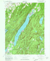
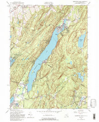
1954 Map of Greenwood Lake
USGS Topo · Published 1981About this map
The New York and New Jersey state line bisects Greenwood Lake in this mid-century topographic study, capturing the rugged borderlands where Orange and Passaic counties meet. To the south, the industrial history of the region is evident near Ringwood, where an Inactive Iron Mine and the Ringwood Mill Pond sit adjacent to Ringwood Manor State Park. The map documents a landscape defined by seasonal camps and growing lakefront communities, including Sterling Forest, Awosting, and Lakeside.
Find a feature on this map
65 named features on this map. Tap any name to fly to it.
Don’t see what you’re looking for? This feature index may not catch every label — zoom into the map to look around manually.
Map Details
Editions of this 1954 Greenwood Lake Map
5 editions found
Other maps of this area

1891 · Greenwood Lake
USGS Topo · 1:62,500

1891 · Ramapo
USGS Topo · 1:62,500

1893 · Greenwood Lake
USGS Topo · 1:62,500

1893 · Ramapo
USGS Topo · 1:62,500

1902 · Schunemunk
USGS Topo · 1:62,500

1903 · Greenwood Lake
USGS Topo · 1:62,500

1906 · Goshen
USGS Topo · 1:62,500

1908 · Goshen
USGS Topo · 1:62,500

1910 · Ramapo
USGS Topo · 1:62,500

1910 · Greenwood Lake
USGS Topo · 1:62,500