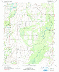
1968 Map of Gregory
USGS Topo · Published 1990About this map
Cache River oxbows and bottomland sloughs dominate this late-1960s landscape in Woodruff County, where the intricate hydrology of Horseshoe Lake, Brusky Lake, and Beaver Lake reflects a legacy of shifting river channels. The settlement of Gregory sits at the heart of this alluvial plain, supported by a network of small landing strips including the Mary Stanley Landing Strip. The map reveals a deeply rooted rural community evidenced by its dispersed houses of worship, such as St Paul Ch and Bethlehem Ch, and numerous family-named burial grounds like Watson Cem and Crutcher Cem. Highlighting the local agricultural infrastructure, the survey notes technical features such as a Siphon Well and Flume near Moore Creek, alongside a Pipeline cutting across the southeastern corner. This record of the Arkansas delta captures the area before modern industrial drainage significantly altered the seasonal wetlands and timbered flats of the Point township.
Find a feature on this map
39 named features on this map. Tap any name to fly to it.
Don’t see what you’re looking for? This feature index may not catch every label — zoom into the map to look around manually.
Map Details
Editions of this 1968 Gregory Map
3 editions found
Other maps of this area

1935 · Augusta
USGS Topo · 1:62,500

1935 · Gregory
USGS Topo · 1:62,500

1939 · Hunter
USGS Topo · 1:62,500

1940 · Tilton
USGS Topo · 1:62,500

1953 · Memphis
USGS Topo · 1:250,000

1956 · Memphis
USGS Topo · 1:250,000

1956 · Tilton
USGS Topo · 1:62,500

1956 · Hunter
USGS Topo · 1:62,500

1957 · Augusta
USGS Topo · 1:62,500

1957 · Gregory
USGS Topo · 1:62,500