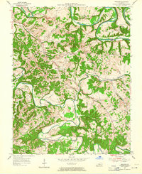
1953 Map of Gresham
USGS Topo · Published 1965About this map
The Green River carves dramatic loops through the northern Kentucky landscape, defining the sharp turns of Cox Bend, Penitentiary Bend, and Lemon Bend. This mid-century survey captures a rural environment structured by the Jane Todd Crawford Trail and an intricate network of creeks, including Russell Creek and the Caney Fork. The settlement pattern is characterized by small upland communities such as Gresham and Roachville, where local life centered around institutions like Ebenezer Ch and the Pleasant Hill Sch.
Find a feature on this map
47 named features on this map. Tap any name to fly to it.
Don’t see what you’re looking for? This feature index may not catch every label — zoom into the map to look around manually.
Map Details
Editions of this 1953 Gresham Map
4 editions found

Other maps of this area

1953 · Gradyville
USGS Topo · 1:24,000

1953 · Campbellsville
USGS Topo · 1:24,000

1953 · Summersville
USGS Topo · 1:24,000

1953 · Exie
USGS Topo · 1:24,000

1953 · Gresham
USGS Topo · 1:24,000

1953 · East Fork
USGS Topo · 1:24,000

1953 · Cane Valley
USGS Topo · 1:24,000

1954 · Columbia
USGS Topo · 1:24,000

1954 · Greensburg
USGS Topo · 1:24,000

1957 · Winchester
USGS Topo · 1:250,000