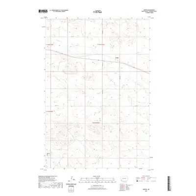
2020 Map of Griffin
USGS Topo · Published 2020About this map
Griffin serves as the central point of interest in this western North Dakota landscape, situated along a transportation corridor that includes both modern routes and the legacy of Old Hwy 12. The terrain is defined by the prominent Medicine Pole Hills in the southwest, rising above a network of seasonal watercourses. Drainage for the region is provided by several distinct streams, including the eastward-flowing Spring Cr, the winding Cold Turkey Cr, and the headwaters of E Fork Deep Cr. The map details a typical High Plains section-line road grid, where routes like 153rd Ave SW and Griffin Rd provide access to the expansive ranching and farming tracts that characterize Bowman County. This survey effectively documents the intersection of rural infrastructure and the natural topography of the Missouri Plateau.
Find a feature on this map
14 named features on this map. Tap any name to fly to it.
Don’t see what you’re looking for? This feature index may not catch every label — zoom into the map to look around manually.
Map Details
Editions of this 2020 Griffin Map
This is the sole edition of this map. No revisions or reprints were ever made.
Other maps of this area

1953 · Dickinson
USGS Topo · 1:250,000

1957 · Dickinson
USGS Topo · 1:250,000

1968 · Bowman SW
USGS Topo · 1:24,000

1968 · Bowman
USGS Topo · 1:24,000

1973 · Camel Butte
USGS Topo · 1:24,000
1973 · Rhame SE
USGS Topo · 1:24,000

1973 · Stewart Lake
USGS Topo · 1:24,000

1973 · Griffin
USGS Topo · 1:24,000

1973 · Rhame
USGS Topo · 1:24,000

1979 · Ives
USGS Topo · 1:24,000