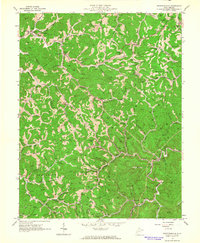
1962 Map of Griffithsville
USGS Topo · Published 1964About this map
Griffithsville and the surrounding hollows of Lincoln Co and Boone Co appear here during a period of extensive energy extraction. Hundreds of Oil Wells and Gas Wells are meticulously documented across the landscape, concentrated heavily near settlements like Yawkey and Sumerco. The map reveals a community structured around narrow valley bottoms and steep ridgelines, where family names are preserved in dozens of small burial grounds such as May Cem, Duvall Cem, and Sias Cem.
Find a feature on this map
106 named features on this map. Tap any name to fly to it.
Don’t see what you’re looking for? This feature index may not catch every label — zoom into the map to look around manually.
Map Details
Editions of this 1962 Griffithsville Map
3 editions found
Other maps of this area

1892 · Huntington
USGS Topo · 1:125,000

1898 · Huntington
USGS Topo · 1:125,000

1899 · Charleston
USGS Topo · 1:125,000

1902 · Milton
USGS Topo · 1:62,500

1902 · Midkiff
USGS Topo · 1:62,500

1907 · Midkiff
USGS Topo · 1:62,500

1909 · Midkiff
USGS Topo · 1:62,500

1909 · Saint Albans
USGS Topo · 1:62,500

1911 · Madison
USGS Topo · 1:62,500

1929 · Madison
USGS Topo · 1:62,500