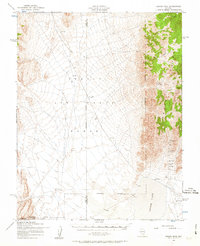
1952 Map of Groom Mine
USGS Topo · Published 1963About this map
Groom Mine and the Black Metal Mine anchor the eastern slopes of the Groom Range in this 1952 study. This high-desert landscape is defined by its transition from industrial mining to mid-century military operations, with the Nellis Air Force Range and the Nevada Test Site occupying the western and southern reaches. To the east, the vast expanse of Groom Lake provides a stark contrast to the mountainous terrain, serviced by a remote Landing Strip and Landing Field.
Find a feature on this map
15 named features on this map. Tap any name to fly to it.
Don’t see what you’re looking for? This feature index may not catch every label — zoom into the map to look around manually.
Map Details
Editions of this 1952 Groom Mine Map
3 editions found

Other maps of this area

1908 · Kawich
USGS Topo · 1:250,000

1942 · Emigrant Valley
USGS Topo · 1:125,000

1942 · Reveille Peak
USGS Topo · 1:125,000

1942 · Wheelbarrow Peak
USGS Topo · 1:125,000

1942 · Penoyer Valley
USGS Topo · 1:125,000

1952 · Tippipah Spring
USGS Topo · 1:62,500

1952 · Papoose Lake
USGS Topo · 1:62,500

1952 · White Blotch Springs
USGS Topo · 1:62,500

1952 · Wheelbarrow Peak
USGS Topo · 1:62,500

1952 · Belted Peak
USGS Topo · 1:62,500