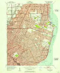
1952 Map of Grosse Pointe
USGS Topo · Published 1953About this map
Lake St Clair forms the eastern boundary of this mid-century portrait of suburban expansion northeast of Detroit. The map illustrates the dense residential platting and burgeoning institutional infrastructure of the post-war era, specifically within the various Grosse Pointe communities and inland toward East Detroit and Roseville. A massive concentration of local schools, such as Poupard Sch and South Lake High Sch, along with several parochial centers like Assumption Sch & Cem, reveals a landscape rapidly adapting to the Baby Boom population surge. Along the shoreline, recreational development is prominent, anchored by the Grosse Pointe Yacht Club at Gaukler Point and the Crescent Sail Yacht Club. Inland, the transition from urban density to more open green spaces is visible through several recreational sites, including the Lochmoor Country Club and the sprawling Chandler Park with its Municipal Golf Course.
Find a feature on this map
113 named features on this map. Tap any name to fly to it.
Don’t see what you’re looking for? This feature index may not catch every label — zoom into the map to look around manually.
Map Details
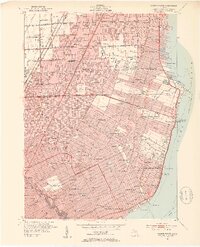
Editions of this 1952 Grosse Pointe Map
2 editions found
Other maps of this area

1905 · Detroit
USGS Topo · 1:62,500

1905 · Grosse Pointe
USGS Topo · 1:62,500

1908 · Rochester
USGS Topo · 1:62,500

1912 · Mt Clemens
USGS Topo · 1:62,500

1918 · Detroit
USGS Topo · 1:62,500

1918 · Grosse Pointe
USGS Topo · 1:62,500

1924 · Detroit
USGS Topo · 1:62,500

1929 · Mt Clemens
USGS Topo · 1:62,500

1934 · Detroit
USGS Topo · 1:62,500

1936 · Warren
USGS Topo · 1:31,680