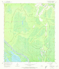
1953 Map of Grosse Tete SW
USGS Topo · Published 1973About this map
Atchafalaya Floodway dominates the lower southwest corner of this Iberville Parish terrain, defined by the massive East Protection Levee and its associated Spoil Bank. The landscape is a complex network of wetlands and drainage, where the Upper Flat sits adjacent to the flood control structures that manage the waters of the Atchafalaya basin. This 1950s survey captures the region's intricate hydrology, featuring numerous named waterways such as Bogan Bayou, Hooper Bayou, and Bayou Henry. These natural bayous are interspersed with man-made interventions like the Catfish Canal and Superior Canal, illustrating the mid-century efforts to regulate water flow for local industry and flood prevention. Inland water bodies like Halfway Lake and Smith Lake remain isolated among the low-lying swamps, while Bayou Grosse Tete snakes along the eastern boundary, serving as a primary corridor through the dense bayou country.
Find a feature on this map
20 named features on this map. Tap any name to fly to it.
Don’t see what you’re looking for? This feature index may not catch every label — zoom into the map to look around manually.
Map Details
Editions of this 1953 Grosse Tete SW Map
4 editions found

Other maps of this area

1935 · Osca Bayou
USGS Topo · 1:62,500

1935 · Chicot Lake
USGS Topo · 1:62,500

1940 · Grosse Tete
USGS Topo · 1:62,500

1941 · Loreauville
USGS Topo · 1:62,500

1953 · Crescent
USGS Topo · 1:24,000

1953 · Cow Bayou
USGS Topo · 1:24,000

1953 · Lobdell
USGS Topo · 1:24,000

1953 · Pigeon Bay
USGS Topo · 1:24,000

1953 · Maringouin
USGS Topo · 1:24,000

1953 · Addis
USGS Topo · 1:24,000