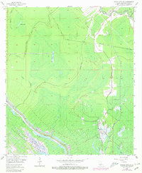
1953 Map of Grosse Tete SW
USGS Topo · Published 1980About this map
Moonshine Field stands at the center of this Iberville Parish landscape, illustrating the mid-century industrial footprint within the Louisiana wetlands. Surveyed in the early 1950s and updated in 1980, the area is defined by a complex hydraulic network designed for flood control and drainage. The southwestern portion is dominated by the Atchafalaya Upper Flat Floodway, bounded by a substantial Protection Levee and the winding course of Bayou Maringouin. North and east of the levee, the map reveals a wilderness of cypress swamps and bayous, including Halfway Lake and Smith Lake. Human modification of the terrain is evident in the straight lines of the Catfish Canal and Superior Canal, as well as the prominent Trinity Spoil Bank. These features, alongside numerous pipelines and firelines, show the systematic management of the Atchafalaya Basin for both resource extraction and water management during this era.
Find a feature on this map
25 named features on this map. Tap any name to fly to it.
Don’t see what you’re looking for? This feature index may not catch every label — zoom into the map to look around manually.
Map Details
Editions of this 1953 Grosse Tete SW Map
4 editions found

Other maps of this area

1935 · Osca Bayou
USGS Topo · 1:62,500

1935 · Chicot Lake
USGS Topo · 1:62,500

1940 · Grosse Tete
USGS Topo · 1:62,500

1941 · Loreauville
USGS Topo · 1:62,500

1953 · Crescent
USGS Topo · 1:24,000

1953 · Cow Bayou
USGS Topo · 1:24,000

1953 · Lobdell
USGS Topo · 1:24,000

1953 · Pigeon Bay
USGS Topo · 1:24,000

1953 · Maringouin
USGS Topo · 1:24,000

1953 · Addis
USGS Topo · 1:24,000