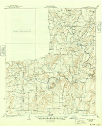
1927 Map of Grosvenor
USGS Topo · Published 1949About this map
Pecan Bayou and its winding tributaries, including Big Bayou and Rough Bayou, dominate this rural Texas landscape during the mid-1920s. The settlement of Grosvenor sits near the headwaters of Dry Creek, while the village of Thrifty is positioned further south along the Jim Ned Creek drainage. This survey, conducted by C.W. Goodlove and his team, reveals a country economy deeply tied to the land and water, evidenced by numerous river crossings like Frys Ford and Turner Ford.
Find a feature on this map
49 named features on this map. Tap any name to fly to it.
Don’t see what you’re looking for? This feature index may not catch every label — zoom into the map to look around manually.
Map Details
Editions of this 1927 Grosvenor Map
2 editions found
Other maps of this area

1887 · Coleman
USGS Topo · 1:125,000

1889 · Brownwood
USGS Topo · 1:125,000

1889 · Coleman
USGS Topo · 1:125,000

1894 · Eastland
USGS Topo · 1:125,000

1894 · Brownwood
USGS Topo · 1:125,000

1924 · Coleman 1-a
USGS Topo · 1:48,000

1924 · Brownwood Reservoir Site
USGS Topo · 1:48,000

1925 · Brownwood 3-b
USGS Topo · 1:48,000

1927 · Grosvenor
USGS Topo · 1:62,500

1928 · Zephyr
USGS Topo · 1:62,500