
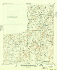
1927 Map of Grosvenor
USGS Topo · Published 1927About this map
The boundary between Coleman and Brown Counties defines this Central Texas landscape, which is marked by a transition from the rugged drainage of Pecan Bayou to the high elevations of Cedar Ridge. Small agrarian communities like Grosvenor, Thrifty, and Byrds serve as focal points for a network of early roads, including the Coleman and Comanche Road and the Cross Plains and Brownwood Road.
Find a feature on this map
44 named features on this map. Tap any name to fly to it.
Don’t see what you’re looking for? This feature index may not catch every label — zoom into the map to look around manually.
Map Details
Editions of this 1927 Grosvenor Map
2 editions found
Other maps of this area

1887 · Coleman
USGS Topo · 1:125,000

1889 · Brownwood
USGS Topo · 1:125,000

1889 · Coleman
USGS Topo · 1:125,000

1894 · Eastland
USGS Topo · 1:125,000

1894 · Brownwood
USGS Topo · 1:125,000

1924 · Coleman 1-a
USGS Topo · 1:48,000

1924 · Brownwood Reservoir Site
USGS Topo · 1:48,000

1925 · Brownwood 3-b
USGS Topo · 1:48,000

1928 · Zephyr
USGS Topo · 1:62,500

1931 · Baird
USGS Topo · 1:125,000