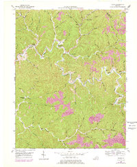
1951 Map of Guage
USGS Topo · Published 1978About this map
Quicksand Creek winds through this corner of the Cumberland Plateau, defining a landscape of deep hollows and narrow ridges along the Magoffin and Breathitt county line. The settlement pattern follows the serpentine watercourses, with small communities like Guage and Rousseau serving as focal points for the surrounding rural families. The map is particularly rich for genealogical research, documenting numerous family burial grounds such as the Mc Quinn Cem, Roark Cem, and Crafts Cems tucked into the hillsides.
Find a feature on this map
89 named features on this map. Tap any name to fly to it.
Don’t see what you’re looking for? This feature index may not catch every label — zoom into the map to look around manually.
Map Details
Editions of this 1951 Guage Map
4 editions found
Other maps of this area

1889 · Salyersville
USGS Topo · 1:125,000

1891 · Hazard
USGS Topo · 1:125,000

1891 · Salyersville
USGS Topo · 1:125,000

1899 · Salyersville
USGS Topo · 1:125,000

1913 · Buckhorn
USGS Topo · 1:62,500

1914 · Troublesome
USGS Topo · 1:62,500

1951 · Tiptop
USGS Topo · 1:24,000

1951 · Guage
USGS Topo · 1:24,000

1951 · Seitz
USGS Topo · 1:24,000

1951 · Quicksand
USGS Topo · 1:24,000