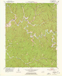
1951 Map of Guage
USGS Topo · Published 1977About this map
Quicksand Creek winds through this section of the Kentucky coalfields, forming the primary artery for small settlements like Guage and Rousseau. The landscape is defined by a dense network of hollows and forks, where local life centered around rural institutions such as the Big Caney Ch and numerous mountain schools, including the Wolf Creek Sch and Richie Sch. The map reveals a deeply personal geography, with family names attached to nearly every topographic feature and burial ground, from the Crafts Cems on the ridges to the Mc Quinn Cem near the creek beds. At Camp Lewis, the terrain levels slightly, providing a rare communal space amidst the steep drainages of Caney Creek and Calhoun Fork. This document preserves the locations of early 1950s farmsteads and rural infrastructure just as the region’s traditional settlement patterns remained firmly intact.
Find a feature on this map
76 named features on this map. Tap any name to fly to it.
Don’t see what you’re looking for? This feature index may not catch every label — zoom into the map to look around manually.
Map Details
Editions of this 1951 Guage Map
4 editions found
Other maps of this area

1889 · Salyersville
USGS Topo · 1:125,000

1891 · Hazard
USGS Topo · 1:125,000

1891 · Salyersville
USGS Topo · 1:125,000

1899 · Salyersville
USGS Topo · 1:125,000

1913 · Buckhorn
USGS Topo · 1:62,500

1914 · Troublesome
USGS Topo · 1:62,500

1951 · Tiptop
USGS Topo · 1:24,000

1951 · Guage
USGS Topo · 1:24,000

1951 · Seitz
USGS Topo · 1:24,000

1951 · Quicksand
USGS Topo · 1:24,000