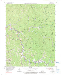
1954 Map of Noble
USGS Topo · Published 1989About this map
Troublesome Creek and Buckhorn Creek anchor this mid-century survey of the Eastern Kentucky coalfields, where the landscape is defined by tight hollows and family-named landmarks. The area around Stacy (Rowdy PO) and Ary PO shows a pattern of settlement closely tied to the watercourses, with numerous family cemeteries like Harvey Cem and Fugate Cem dotting the ridges above the valley floors. The presence of the Camp Robinson University of Kentucky Engineering Camp and the Bethel Childrens Home points to the specialized land use in this part of Breathitt County during the early 1950s.
Find a feature on this map
114 named features on this map. Tap any name to fly to it.
Don’t see what you’re looking for? This feature index may not catch every label — zoom into the map to look around manually.
Map Details
Editions of this 1954 Noble Map
4 editions found
Other maps of this area

1889 · Salyersville
USGS Topo · 1:125,000

1891 · Hazard
USGS Topo · 1:125,000

1891 · Salyersville
USGS Topo · 1:125,000

1899 · Salyersville
USGS Topo · 1:125,000

1913 · Buckhorn
USGS Topo · 1:62,500

1914 · Troublesome
USGS Topo · 1:62,500

1951 · Tiptop
USGS Topo · 1:24,000

1951 · Guage
USGS Topo · 1:24,000

1951 · Quicksand
USGS Topo · 1:24,000

1954 · Noble
USGS Topo · 1:24,000