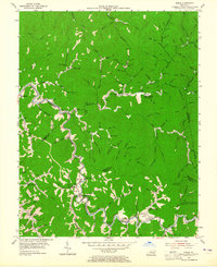
1954 Map of Noble
USGS Topo · Published 1965About this map
Stacy (Rowdy PO) and Ary PO anchor this mid-century survey of the Cumberland Plateau's deeply etched valleys along the border of Breathitt, Perry, and Knott counties. The landscape is defined by the winding course of Troublesome Creek and its countless tributaries like Clemons Fork and Lewis Creek, where small settlements and family farms clustered. This era captures a traditional Appalachian social infrastructure, with numerous country schools such as Ball Sch and Cockerell Fork Sch, alongside religious and social hubs like Philadelphia Ch and the Homeplace Community Center.
Find a feature on this map
156 named features on this map. Tap any name to fly to it.
Don’t see what you’re looking for? This feature index may not catch every label — zoom into the map to look around manually.
Map Details
Editions of this 1954 Noble Map
4 editions found
Other maps of this area

1889 · Salyersville
USGS Topo · 1:125,000

1891 · Hazard
USGS Topo · 1:125,000

1891 · Salyersville
USGS Topo · 1:125,000

1899 · Salyersville
USGS Topo · 1:125,000

1913 · Buckhorn
USGS Topo · 1:62,500

1914 · Troublesome
USGS Topo · 1:62,500

1951 · Tiptop
USGS Topo · 1:24,000

1951 · Guage
USGS Topo · 1:24,000

1951 · Quicksand
USGS Topo · 1:24,000

1954 · Noble
USGS Topo · 1:24,000