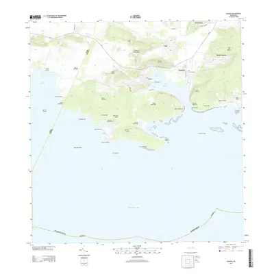
2013 Map of Guanica
USGS Topo · Published 2013About this map
Guánica and its deep-water harbor anchor this coastal survey, reflecting a landscape defined by its relation to the Caribbean Sea. The town is dominated by the Central Guánica site, a nod to the area's sugar industry heritage, while several salt-related settlements like Salinas Providencia and Salinas Las Pardas dot the jagged coastline. The topography is characterized by distinctive coastal hills, including Cerro Caprón and Monte de la Brea, which overlook a complex series of inlets such as Bahía de Guánica and Ensenada las Pardas. Inland, the agricultural and residential pockets of Fuig, María Antonia, and Sabana Montalva are connected by the PR-116 corridor. The Río Loco flows through the northeast, providing a vital freshwater source to this otherwise arid, peninsula-heavy terrain of the Island of Puerto Rico.
Find a feature on this map
51 named features on this map. Tap any name to fly to it.
Don’t see what you’re looking for? This feature index may not catch every label — zoom into the map to look around manually.
Map Details
Editions of this 2013 Guanica Map
This is the sole edition of this map. No revisions or reprints were ever made.
Other maps of this area

1937 · San German
USGS Topo · 1:25,000

1937 · Sabana Grande
USGS Topo · 1:25,000

1938 · Guanica
USGS Topo · 1:30,000

1938 · Parguera
USGS Topo · 1:30,000

1941 · San German
USGS Topo · 1:30,000

1941 · Sabana Grande
USGS Topo · 1:30,000

1946 · Yauco
USGS Topo · 1:30,000

1946 · Punta Verraco
USGS Topo · 1:30,000
1947 · Yauco SO
USGS Topo · 1:10,000
1949 · Guanica NE
USGS Topo · 1:10,000