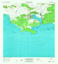
1956 Map of Guanica
USGS Topo · Published 1959About this map
Industrial and salt-harvesting operations define this coastal portion of southwest Puerto Rico in the mid-1950s. The prominent Central Guánica sugar mill and the adjacent town of Ensenada serve as the economic hub of the region, situated along the sheltered waters of the Bahia de Guánica. The landscape is a mosaic of steep limestone hills like Cerro Caprón and low-lying coastal flats dedicated to salt production, including Salinas Providencia and Salinas Las Pardas. Along the shoreline, maritime navigation is anchored by the Faro de Guánica near the entrance to the bay. Educational and social life is marked by the Escuela José Gautier Benitez and Escuela Las Colinas, while the rugged southern peninsula terminates at the prominent Frontón de la Brea, shielding the tranquil Ensenada Las Pardas.
Find a feature on this map
66 named features on this map. Tap any name to fly to it.
Don’t see what you’re looking for? This feature index may not catch every label — zoom into the map to look around manually.
Map Details
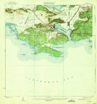
Editions of this 1956 Guanica Map
This is the sole edition of this map. No revisions or reprints were ever made.
Other maps of this area

1937 · San German
USGS Topo · 1:25,000

1937 · Sabana Grande
USGS Topo · 1:25,000
1938 · Guanica
USGS Topo · 1:30,000

1938 · Parguera
USGS Topo · 1:30,000

1941 · San German
USGS Topo · 1:30,000

1941 · Sabana Grande
USGS Topo · 1:30,000

1946 · Yauco
USGS Topo · 1:30,000
1946 · Punta Verraco
USGS Topo · 1:30,000

1947 · Yauco SO
USGS Topo · 1:10,000
1949 · Guanica NE
USGS Topo · 1:10,000