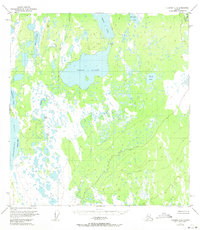
1951 Map of Gulkana B-4
USGS Topo · Published 1971About this map
Ewan Lake dominates this interior Alaskan landscape, which was mapped from 1950 aerial photography and later annotated in the field. The terrain is defined by a dense network of kettle ponds and larger water bodies like Crosswind Lake and Middle Lake. A cluster of Cabins on the northeast shore of Ewan Lake provides evidence of seasonal or remote habitation in this unsurveyed territory of the Copper River Meridian.
Find a feature on this map
14 named features on this map. Tap any name to fly to it.
Don’t see what you’re looking for? This feature index may not catch every label — zoom into the map to look around manually.
Map Details
Editions of this 1951 Gulkana B-4 Map
4 editions found
Historical Maps of Unorganized Borough Through Time
1885 maps found

1948 Cordova
Alaska

1948 Craig D-7 and D-8
Alaska

1948 Middleton Island
Alaska

1948 Nabesna C-6
Alaska

1948 Nabesna D-5
Alaska

1948 Petersburg C-4
Alaska

1948 Petersburg C-5
Alaska

1948 Petersburg C-6
Alaska

1948 Petersburg D-5
Alaska

1948 Petersburg D-6
Alaska

1948 Port Alexander A-1
Alaska

1948 Port Alexander B-1
Alaska

1948 Port Alexander C-1
Alaska

1948 Valdez D-5
Alaska

1949 Gulkana A-3
Alaska

1949 Gulkana B-2
Alaska

1949 Gulkana C-1
Alaska

1949 Gulkana C-2
Alaska

1949 Gulkana D-3
Alaska

1949 Mount Hayes A-4
Alaska

1949 Mt. Hayes A-1
Alaska

1949 Nabesna D-6
Alaska

1949 Valdez D-4
Alaska

1949 Valdez D-6
Alaska

1949 Valdez D-7
Alaska

1950 Cordova A-1
Alaska

1950 Cordova A-2
Alaska

1950 Cordova B-2
Alaska

1950 Cordova B-7
Alaska

1950 Cordova C-4
Alaska

1950 Cordova C-6
Alaska

1950 Cordova C-7
Alaska

1950 Cordova C-8
Alaska

1950 Cordova D-3
Alaska

1950 Cordova D-5
Alaska

1950 Cordova D-7
Alaska

1950 Gulkana B-3
Alaska

1950 Gulkana C-3
Alaska

1950 Gulkana C-4
Alaska

1950 Gulkana D-4
Alaska

1950 McCarthy A-8
Alaska

1950 Middleton Island
Alaska

1950 Mount Hayes A-3
Alaska

1950 Nabesna D-5
Alaska

1950 Nabesna
Alaska

1950 Seward B-3
Alaska

1950 Valdez A-3
Alaska

1950 Valdez C-6
Alaska

1951 Cordova A-7 and A-8
Alaska

1951 Cordova B-1
Alaska

1951 Cordova B-4
Alaska

1951 Cordova B-5
Alaska

1951 Cordova B-6
Alaska

1951 Cordova B-8
Alaska

1951 Cordova C-3
Alaska

1951 Cordova C-5
Alaska

1951 Cordova D-4
Alaska

1951 Cordova D-6
Alaska

1951 Cordova D-8
Alaska

1951 Cordova
Alaska

1951 Gulkana A-4
Alaska

1951 Gulkana B-4
Alaska

1951 McCarthy B-8
Alaska

1951 McCarthy C-8
Alaska

1951 McCarthy
Alaska

1951 Nabesna
Alaska

1951 Petersburg C-4
Alaska

1951 Petersburg C-5
Alaska

1951 Petersburg D-4
Alaska

1951 Petersburg D-6
Alaska

1951 Port Alexander C-1
Alaska

1951 Seward A-1
Alaska

1951 Seward A-2
Alaska

1951 Seward A-3
Alaska

1951 Seward A-4
Alaska

1951 Seward B-1
Alaska

1951 Seward B-2
Alaska

1951 Seward B-4
Alaska

1951 Seward C-1
Alaska

1951 Seward C-2
Alaska

1951 Seward C-3
Alaska

1951 Seward C-4
Alaska

1951 Seward D-1
Alaska

1951 Seward D-2
Alaska

1951 Seward D-3
Alaska

1951 Valdez A-1
Alaska

1951 Valdez A-2
Alaska

1951 Valdez A-6
Alaska

1951 Valdez B-1
Alaska

1951 Valdez B-2
Alaska

1951 Valdez B-3
Alaska

1951 Valdez B-4
Alaska

1951 Valdez B-5
Alaska

1951 Valdez B-6
Alaska

1951 Valdez C-1
Alaska

1951 Valdez C-2
Alaska

1951 Valdez C-3
Alaska

1951 Valdez C-4
Alaska

1951 Valdez C-5
Alaska

1951 Valdez D-5
Alaska

1951 Valdez D-6
Alaska

1951 Valdez D-7
Alaska

1952 Cordova B-3
Alaska

1952 Cordova C-8
Alaska

1952 Cordova D-7
Alaska

1952 Cordova D-8
Alaska

1952 Gulkana A-3
Alaska

1952 Gulkana A-4
Alaska

1952 Gulkana B-2
Alaska

1952 Gulkana B-3
Alaska

1952 Gulkana B-4
Alaska

1952 Gulkana C-1
Alaska

1952 Gulkana C-2
Alaska

1952 Gulkana C-3
Alaska

1952 Gulkana C-4
Alaska

1952 Gulkana D-3
Alaska

1952 Gulkana D-4
Alaska

1952 Mount Hayes A-3
Alaska

1952 Mt. Hayes A-4
Alaska

1952 Mt. Hayes B-4
Alaska

1952 Nabesna C-6
Alaska

1952 Nabesna D-5
Alaska

1952 Nabesna D-6
Alaska

1952 Seward A-3
Alaska

1952 Seward A-4
Alaska

1952 Seward B-1
Alaska

1952 Seward B-2
Alaska

1952 Seward B-3
Alaska

1952 Seward B-4
Alaska

1952 Seward C-1
Alaska

1952 Seward C-2
Alaska

1952 Seward C-3
Alaska

1952 Seward C-4
Alaska

1952 Seward D-1
Alaska

1952 Seward D-2
Alaska

1952 Seward D-3
Alaska

1952 Valdez A-6
Alaska

1952 Valdez D-4
Alaska

1953 Cordova A-1
Alaska

1953 Cordova A-2
Alaska

1953 Cordova A-7 and A-8
Alaska

1953 Cordova B-1
Alaska

1953 Cordova B-2
Alaska

1953 Cordova B-3
Alaska

1953 Cordova B-5
Alaska

1953 Cordova B-6
Alaska

1953 Cordova B-7
Alaska

1953 Cordova B-8
Alaska

1953 Cordova C-3
Alaska

1953 Cordova C-4
Alaska

1953 Cordova C-5
Alaska

1953 Cordova C-6
Alaska

1953 Cordova C-7
Alaska

1953 Cordova D-3
Alaska

1953 Cordova D-4
Alaska

1953 Cordova D-5
Alaska

1953 Cordova D-6
Alaska

1953 Port Alexander B-1
Alaska

1953 Seward A-1
Alaska

1953 Seward A-2
Alaska

1953 Valdez A-3
Alaska

1953 Valdez A-4
Alaska

1953 Valdez A-5
Alaska

1953 Valdez B-4
Alaska

1953 Valdez B-6
Alaska

1953 Valdez C-1
Alaska

1953 Valdez C-2
Alaska

1953 Valdez C-3
Alaska

1953 Valdez C-4
Alaska

1953 Valdez C-5
Alaska

1953 Valdez C-6
Alaska

1954 Gulkana D-1
Alaska

1954 Gulkana D-2
Alaska

1954 Gulkana D-3
Alaska

1954 Mount Hayes A-1
Alaska

1954 Mount Hayes A-3
Alaska

1954 Mount Hayes B-1
Alaska

1954 Mt. Hayes B-4
Alaska

1955 Middleton Island B-7
Alaska

1955 Middleton Island D-1 and D-2
Alaska

1955 Middleton Island
Alaska

1955 Mount Hayes A-2
Alaska

1955 Mount Hayes B-1
Alaska

1955 Mount Hayes B-2
Alaska

1955 Mount Hayes B-3
Alaska

1955 Mt Hayes A-1
Alaska

1957 Nabesna C-5
Alaska

1957 Valdez A-2
Alaska

1958 Valdez D-3
Alaska

1959 Cordova C-1
Alaska

1959 Cordova C-2
Alaska

1959 Cordova D-1
Alaska

1959 Cordova D-2
Alaska

1959 Cordova
Alaska

1959 Gulkana A-1
Alaska

1959 Gulkana A-2
Alaska

1959 Gulkana B-1
Alaska

1959 McCarthy A-1
Alaska

1959 McCarthy A-2
Alaska

1959 McCarthy A-3
Alaska

1959 McCarthy A-4
Alaska

1959 McCarthy A-5
Alaska

1959 McCarthy A-6
Alaska

1959 McCarthy A-7
Alaska

1959 McCarthy B-1
Alaska

1959 McCarthy B-2
Alaska

1959 McCarthy B-3
Alaska

1959 McCarthy B-4
Alaska

1959 McCarthy B-5
Alaska

1959 McCarthy B-6
Alaska

1959 McCarthy B-7
Alaska

1959 McCarthy C-1
Alaska

1959 McCarthy C-2
Alaska

1959 McCarthy C-3
Alaska

1959 McCarthy C-4
Alaska

1959 McCarthy C-5
Alaska

1959 McCarthy C-6
Alaska

1959 McCarthy C-7
Alaska

1959 McCarthy D-1
Alaska

1959 McCarthy D-2
Alaska

1959 McCarthy D-3
Alaska

1959 McCarthy D-7
Alaska

1959 Nabesna A-4
Alaska

1959 Nabesna A-5
Alaska

1959 Nabesna A-6
Alaska

1959 Valdez D-1
Alaska

1959 Valdez D-2
Alaska

1960 Anchorage A-1
Alaska

1960 Anchorage A-2
Alaska

1960 Anchorage A-3
Alaska

1960 McCarthy D-4
Alaska

1960 McCarthy D-5
Alaska

1960 McCarthy D-6
Alaska

1960 McCarthy D-8
Alaska

1960 McCarthy
Alaska

1960 Nabesna A-3
Alaska

1960 Nabesna B-3
Alaska

1960 Nabesna B-4
Alaska

1960 Nabesna B-5
Alaska

1960 Nabesna B-6
Alaska

1960 Nabesna C-4
Alaska

1960 Nabesna C-5
Alaska

1960 Nabesna
Alaska

1960 Sumdum A-1
Alaska

1960 Valdez A-7
Alaska

1960 Valdez A-8
Alaska

1960 Valdez B-7
Alaska

1960 Valdez C-7
Alaska

1961 Petersburg D-3
Alaska

1961 Sumdum A-2
Alaska

1961 Sumdum A-3
Alaska

1965 Middleton Island
Alaska

1983 Cordova B-4 NW
Alaska

1983 Cordova C-4 SW
Alaska

1983 Cordova C-5 SE
Alaska

1983 Cordova C-5 SW
Alaska

1983 Valdez A-6 NW
Alaska

1983 Valdez A-6 SE
Alaska

1983 Valdez A-6 SW
Alaska

1983 Valdez A-7 NE
Alaska

1983 Valdez A-7 SE
Alaska

1984 Bering Glacier D-1
Alaska

1984 Bering Glacier D-2
Alaska

1984 Bering Glacier D-3
Alaska

1984 Bering Glacier D-4
Alaska

1984 Bering Glacier D-5
Alaska

1984 Bering Glacier D-6
Alaska

1984 Bering Glacier D-7
Alaska

1984 Bering Glacier D-8
Alaska

1985 Bering Glacier B-8
Alaska

1985 Bering Glacier C-1
Alaska

1985 Bering Glacier C-2
Alaska

1985 Bering Glacier C-7
Alaska

1985 Bering Glacier C-8
Alaska

1988 Cordova A-3
Alaska

1988 Cordova A-4
Alaska

1988 Cordova A-7 and A-8
Alaska

1992 Petersburg C-3 NE
Alaska

1992 Petersburg C-3 NW
Alaska

1992 Petersburg C-3 SW
Alaska

1992 Petersburg D-3 SW
Alaska

1992 Petersburg D-4 SE
Alaska

1993 McCarthy C-4
Alaska

1993 McCarthy C-5
Alaska

1993 McCarthy C-6
Alaska

1993 Valdez B-6
Alaska

1993 Valdez C-6
Alaska

1993 Valdez C-7
Alaska

1993 Valdez D-6
Alaska

1993 Valdez D-7
Alaska

1994 Cordova B-4
Alaska

1994 Cordova D-2
Alaska

1994 Cordova D-3
Alaska

1994 Cordova D-6
Alaska

1994 Cordova D-7
Alaska

1994 McCarthy A-4
Alaska

1994 McCarthy A-5
Alaska

1994 McCarthy A-6
Alaska

1994 McCarthy B-4
Alaska

1994 McCarthy B-6
Alaska

1994 Seward B-4
Alaska

1994 Valdez A-3
Alaska

1994 Valdez A-4
Alaska

1994 Valdez B-4
Alaska

1995 Anchorage A-1
Alaska

1995 McCarthy B-7
Alaska

1995 McCarthy B-8
Alaska

1995 McCarthy C-7
Alaska

1995 McCarthy C-8
Alaska

1995 Middleton Island D-1 and D-2
Alaska

1995 Petersburg C-4
Alaska

1995 Petersburg D-3
Alaska

1995 Petersburg D-4
Alaska

1995 Petersburg D-6
Alaska

1995 Seward C-3
Alaska

1995 Seward C-4
Alaska

1995 Seward D-1
Alaska

1995 Seward D-3
Alaska

1995 Valdez A-1
Alaska

1995 Valdez A-2
Alaska

1995 Valdez A-8
Alaska

1995 Valdez B-1
Alaska

1995 Valdez B-3
Alaska

1995 Valdez B-5
Alaska

1996 Valdez A-7
Alaska

1996 Valdez C-2
Alaska

1996 Valdez C-3
Alaska

1996 Valdez C-4
Alaska

1996 Valdez C-5
Alaska

1996 Valdez D-1
Alaska

1996 Valdez D-2
Alaska

1996 Valdez D-3
Alaska

1996 Valdez D-4
Alaska

1996 Valdez D-5
Alaska

1997 Cordova A-2
Alaska

1997 Cordova B-1
Alaska

1997 Cordova B-2
Alaska

1997 Cordova B-7
Alaska

1997 Port Alexander C-1
Alaska

1997 Seward A-1
Alaska

1997 Seward B-1
Alaska

1997 Seward D-2
Alaska

2000 Cordova B-5
Alaska

2000 Cordova C-4
Alaska

2000 Cordova C-5
Alaska

2000 Cordova C-6
Alaska

2000 Cordova C-7
Alaska

2000 Seward A-3
Alaska

2000 Seward A-4
Alaska

2000 Seward B-3
Alaska

2000 Sumdum A-2
Alaska

2013 Anchorage A-1 NW
Alaska

2013 Anchorage A-2 NE
Alaska

2013 Anchorage A-2 NW
Alaska

2013 Anchorage A-3 NE
Alaska

2013 Anchorage A-3 NW
Alaska

2013 Anchorage A-4 NE
Alaska

2013 Anchorage B-1 SW
Alaska

2013 Anchorage B-2 SE
Alaska

2013 Anchorage B-2 SW
Alaska

2013 Anchorage B-3 SE
Alaska

2013 Anchorage B-3 SW
Alaska

2013 Anchorage B-4 SE
Alaska

2013 Gulkana A-6 SE
Alaska

2013 Gulkana B-3 SW
Alaska

2013 Gulkana B-4 NE
Alaska

2013 Gulkana B-4 SE
Alaska

2014 Bering Glacier A-8 NW
Alaska

2014 Bering Glacier B-7 NW
Alaska

2014 Bering Glacier B-8 NE
Alaska

2014 Bering Glacier B-8 NW
Alaska

2014 Bering Glacier B-8 SE
Alaska

2014 Bering Glacier B-8 SW
Alaska

2014 Bering Glacier C-6 NW
Alaska

2014 Bering Glacier C-7 NE
Alaska

2014 Bering Glacier C-7 NW
Alaska

2014 Bering Glacier C-7 SE
Alaska

2014 Bering Glacier C-7 SW
Alaska

2014 Bering Glacier C-8 NE
Alaska

2014 Bering Glacier C-8 NW
Alaska

2014 Bering Glacier C-8 SE
Alaska

2014 Bering Glacier C-8 SW
Alaska

2014 Bering Glacier D-6 NW
Alaska

2014 Bering Glacier D-6 SW
Alaska

2014 Bering Glacier D-7 NE
Alaska

2014 Bering Glacier D-7 SE
Alaska

2014 Bering Glacier D-7 SW
Alaska

2014 Bering Glacier D-8 SE
Alaska

2014 Bering Glacier D-8 SW
Alaska

2014 Cordova A-1 NW
Alaska

2014 Cordova A-1 SE
Alaska

2014 Cordova A-2 NE
Alaska

2014 Cordova A-2 NW
Alaska

2014 Cordova A-3 NE
Alaska

2014 Cordova A-3 NW
Alaska

2014 Cordova A-4 NE
Alaska

2014 Cordova B-1 NE
Alaska

2014 Cordova B-1 NW
Alaska

2014 Cordova B-1 SW
Alaska

2014 Cordova B-2 NE
Alaska

2014 Cordova B-2 NW
Alaska

2014 Cordova B-2 SE
Alaska

2014 Cordova B-2 SW
Alaska

2014 Cordova B-3 NE
Alaska

2014 Cordova B-3 NW
Alaska

2014 Cordova B-3 SE
Alaska

2014 Cordova B-3 SW
Alaska

2014 Cordova B-4 NE
Alaska

2014 Cordova B-4 NW
Alaska

2014 Cordova B-4 SE
Alaska

2014 Cordova B-4 SW
Alaska

2014 Cordova B-5 NE
Alaska

2014 Cordova B-5 NW
Alaska

2014 Cordova B-5 SE
Alaska

2014 Cordova B-5 SW
Alaska

2014 Cordova C-1 NE
Alaska

2014 Cordova C-1 NW
Alaska

2014 Cordova C-1 SE
Alaska

2014 Cordova C-1 SW
Alaska

2014 Cordova C-2 NE
Alaska

2014 Cordova C-2 NW
Alaska

2014 Cordova C-2 SE
Alaska

2014 Cordova C-2 SW
Alaska

2014 Cordova C-3 NE
Alaska

2014 Cordova C-3 NW
Alaska

2014 Cordova C-3 SE
Alaska

2014 Cordova C-3 SW
Alaska

2014 Cordova C-4 NE
Alaska

2014 Cordova C-4 NW
Alaska

2014 Cordova C-4 SE
Alaska

2014 Cordova C-4 SW
Alaska

2014 Cordova C-5 NE
Alaska

2014 Cordova C-5 NW
Alaska

2014 Cordova C-5 SE
Alaska

2014 Cordova C-5 SW
Alaska

2014 Cordova D-1 NE
Alaska

2014 Cordova D-1 SE
Alaska

2014 Cordova D-1 SW
Alaska

2014 Cordova D-2 SE
Alaska

2014 Cordova D-2 SW
Alaska

2014 Cordova D-3 NE
Alaska

2014 Cordova D-3 NW
Alaska

2014 Cordova D-3 SE
Alaska

2014 Cordova D-3 SW
Alaska

2014 Cordova D-4 NE
Alaska

2014 Cordova D-4 NW
Alaska

2014 Cordova D-4 SE
Alaska

2014 Cordova D-4 SW
Alaska

2014 Cordova D-5 NE
Alaska

2014 Cordova D-5 NW
Alaska

2014 Cordova D-5 SE
Alaska

2014 Cordova D-5 SW
Alaska

2015 Cordova A-1 NE
Alaska

2015 Cordova A-1 SW
Alaska

2015 Cordova B-1 SE
Alaska

2016 Anchorage A-1 NE
Alaska

2016 Anchorage A-1 SE
Alaska

2016 Anchorage A-1 SW
Alaska

2016 Anchorage A-2 SE
Alaska

2016 Anchorage A-2 SW
Alaska

2016 Anchorage A-3 SE
Alaska

2016 Anchorage A-3 SW
Alaska

2016 Anchorage A-4 SE
Alaska

2016 Anchorage B-1 SE
Alaska

2016 Bering Glacier C-4 NE
Alaska

2016 Bering Glacier C-4 NW
Alaska

2016 Bering Glacier C-5 NE
Alaska

2016 Bering Glacier C-5 NW
Alaska

2016 Bering Glacier C-6 NE
Alaska

2016 Bering Glacier D-4 NE
Alaska

2016 Bering Glacier D-4 NW
Alaska

2016 Bering Glacier D-4 SE
Alaska

2016 Bering Glacier D-4 SW
Alaska

2016 Bering Glacier D-5 NE
Alaska

2016 Bering Glacier D-5 NW
Alaska

2016 Bering Glacier D-5 SE
Alaska

2016 Bering Glacier D-5 SW
Alaska

2016 Bering Glacier D-6 NE
Alaska

2016 Bering Glacier D-6 SE
Alaska

2016 Bering Glacier D-7 NW
Alaska

2016 Bering Glacier D-8 NE
Alaska

2016 Bering Glacier D-8 NW
Alaska

2016 Cordova D-1 NW
Alaska

2016 Cordova D-2 NE
Alaska

2016 Cordova D-2 NW
Alaska

2016 Gulkana A-1 NE
Alaska

2016 Gulkana A-1 NW
Alaska

2016 Gulkana A-1 SE
Alaska

2016 Gulkana A-1 SW
Alaska

2016 Gulkana A-2 NE
Alaska

2016 Gulkana A-2 NW
Alaska

2016 Gulkana A-2 SE
Alaska

2016 Gulkana A-2 SW
Alaska

2016 Gulkana A-3 NE
Alaska

2016 Gulkana A-3 NW
Alaska

2016 Gulkana A-3 SE
Alaska

2016 Gulkana A-3 SW
Alaska

2016 Gulkana A-4 NE
Alaska

2016 Gulkana A-4 NW
Alaska

2016 Gulkana A-4 SE
Alaska

2016 Gulkana A-4 SW
Alaska

2016 Gulkana A-5 NE
Alaska

2016 Gulkana A-5 SE
Alaska

2016 Gulkana A-5 SW
Alaska

2016 Gulkana B-1 NE
Alaska

2016 Gulkana B-1 NW
Alaska

2016 Gulkana B-1 SE
Alaska

2016 Gulkana B-1 SW
Alaska

2016 Gulkana B-2 NE
Alaska

2016 Gulkana B-2 NW
Alaska

2016 Gulkana B-2 SE
Alaska

2016 Gulkana B-2 SW
Alaska

2016 Gulkana B-3 NE
Alaska

2016 Gulkana B-3 NW
Alaska

2016 Gulkana B-3 SE
Alaska

2016 Gulkana B-4 NW
Alaska

2016 Gulkana B-4 SW
Alaska

2016 Gulkana B-5 NE
Alaska

2016 Gulkana B-5 SE
Alaska

2016 Gulkana C-1 NE
Alaska

2016 Gulkana C-1 NW
Alaska

2016 Gulkana C-1 SE
Alaska

2016 Gulkana C-1 SW
Alaska

2016 Gulkana C-2 NE
Alaska

2016 Gulkana C-2 NW
Alaska

2016 Gulkana C-2 SE
Alaska

2016 Gulkana C-2 SW
Alaska

2016 Gulkana C-3 NE
Alaska

2016 Gulkana C-3 NW
Alaska

2016 Gulkana C-3 SE
Alaska

2016 Gulkana C-3 SW
Alaska

2016 Gulkana C-4 NE
Alaska

2016 Gulkana C-4 NW
Alaska

2016 Gulkana C-4 SE
Alaska

2016 Gulkana C-4 SW
Alaska

2016 Gulkana C-5 NE
Alaska

2016 Gulkana C-5 SE
Alaska

2016 Gulkana D-1 NE
Alaska

2016 Gulkana D-1 NW
Alaska

2016 Gulkana D-1 SE
Alaska

2016 Gulkana D-1 SW
Alaska

2016 Gulkana D-2 NE
Alaska

2016 Gulkana D-2 NW
Alaska

2016 Gulkana D-2 SE
Alaska

2016 Gulkana D-2 SW
Alaska

2016 Gulkana D-3 NE
Alaska

2016 Gulkana D-3 NW
Alaska

2016 Gulkana D-3 SE
Alaska

2016 Gulkana D-3 SW
Alaska

2016 Gulkana D-4 NE
Alaska

2016 Gulkana D-4 NW
Alaska

2016 Gulkana D-4 SE
Alaska

2016 Gulkana D-4 SW
Alaska

2016 Gulkana D-5 NE
Alaska

2016 Gulkana D-5 SE
Alaska

2016 Mount Hayes A-1 NE
Alaska

2016 Mount Hayes A-1 NW
Alaska

2016 Mount Hayes A-1 SE
Alaska

2016 Mount Hayes A-1 SW
Alaska

2016 Mount Hayes A-2 NE
Alaska

2016 Mount Hayes A-2 NW
Alaska

2016 Mount Hayes A-2 SE
Alaska

2016 Mount Hayes A-2 SW
Alaska

2016 Mount Hayes A-3 NE
Alaska

2016 Mount Hayes A-3 NW
Alaska

2016 Mount Hayes A-3 SE
Alaska

2016 Mount Hayes A-3 SW
Alaska

2016 Mount Hayes A-4 NE
Alaska

2016 Mount Hayes A-4 NW
Alaska

2016 Mount Hayes A-4 SE
Alaska

2016 Mount Hayes A-4 SW
Alaska

2016 Mount Hayes A-5 NE
Alaska

2016 Mount Hayes A-5 SE
Alaska

2016 Mount Hayes B-1 NE
Alaska

2016 Mount Hayes B-1 NW
Alaska

2016 Mount Hayes B-1 SE
Alaska

2016 Mount Hayes B-1 SW
Alaska

2016 Mount Hayes B-2 NE
Alaska

2016 Mount Hayes B-2 NW
Alaska

2016 Mount Hayes B-2 SE
Alaska

2016 Mount Hayes B-2 SW
Alaska

2016 Mount Hayes B-3 NE
Alaska

2016 Mount Hayes B-3 NW
Alaska

2016 Mount Hayes B-3 SE
Alaska

2016 Mount Hayes B-3 SW
Alaska

2016 Mount Hayes B-4 NE
Alaska

2016 Mount Hayes B-4 NW
Alaska

2016 Mount Hayes B-4 SE
Alaska

2016 Mount Hayes B-4 SW
Alaska

2016 Mount Hayes B-5 NE
Alaska

2016 Mount Hayes B-5 SE
Alaska

2016 Nabesna A-2 SW
Alaska

2016 Nabesna A-3 NE
Alaska

2016 Nabesna A-3 NW
Alaska

2016 Nabesna A-3 SE
Alaska

2016 Nabesna A-3 SW
Alaska

2016 Nabesna A-4 NE
Alaska

2016 Nabesna A-4 NW
Alaska

2016 Nabesna A-4 SE
Alaska

2016 Nabesna A-4 SW
Alaska

2016 Nabesna A-5 NE
Alaska

2016 Nabesna A-5 NW
Alaska

2016 Nabesna A-5 SE
Alaska

2016 Nabesna A-5 SW
Alaska

2016 Nabesna A-6 NE
Alaska

2016 Nabesna A-6 NW
Alaska

2016 Nabesna A-6 SE
Alaska

2016 Nabesna A-6 SW
Alaska

2016 Nabesna B-3 NE
Alaska

2016 Nabesna B-3 NW
Alaska

2016 Nabesna B-3 SE
Alaska

2016 Nabesna B-3 SW
Alaska

2016 Nabesna B-4 NE
Alaska

2016 Nabesna B-4 NW
Alaska

2016 Nabesna B-4 SE
Alaska

2016 Nabesna B-4 SW
Alaska

2016 Nabesna B-5 NE
Alaska

2016 Nabesna B-5 NW
Alaska

2016 Nabesna B-5 SE
Alaska

2016 Nabesna B-5 SW
Alaska

2016 Nabesna B-6 NE
Alaska

2016 Nabesna B-6 NW
Alaska

2016 Nabesna B-6 SE
Alaska

2016 Nabesna B-6 SW
Alaska

2016 Nabesna C-3 SW
Alaska

2016 Nabesna C-4 NE
Alaska

2016 Nabesna C-4 SE
Alaska

2016 Nabesna C-4 SW
Alaska

2016 Nabesna C-5 NE
Alaska

2016 Nabesna C-5 NW
Alaska

2016 Nabesna C-5 SE
Alaska

2016 Nabesna C-5 SW
Alaska

2016 Nabesna C-6 NE
Alaska

2016 Nabesna C-6 NW
Alaska

2016 Nabesna C-6 SE
Alaska

2016 Nabesna C-6 SW
Alaska

2016 Nabesna D-5 NE
Alaska

2016 Nabesna D-5 NW
Alaska

2016 Nabesna D-5 SE
Alaska

2016 Nabesna D-5 SW
Alaska

2016 Nabesna D-6 NE
Alaska

2016 Nabesna D-6 NW
Alaska

2016 Nabesna D-6 SE
Alaska

2016 Nabesna D-6 SW
Alaska

2016 Tanacross A-5 SE
Alaska

2016 Tanacross A-5 SW
Alaska

2016 Tanacross A-6 SE
Alaska

2016 Tanacross A-6 SW
Alaska

2016 Valdez A-1 NE
Alaska

2016 Valdez A-1 NW
Alaska

2016 Valdez A-1 SE
Alaska

2016 Valdez A-1 SW
Alaska

2016 Valdez A-2 NE
Alaska

2016 Valdez A-2 NW
Alaska

2016 Valdez A-2 SE
Alaska

2016 Valdez A-2 SW
Alaska

2016 Valdez A-3 NE
Alaska

2016 Valdez A-3 NW
Alaska

2016 Valdez A-3 SE
Alaska

2016 Valdez A-3 SW
Alaska

2016 Valdez A-4 NE
Alaska

2016 Valdez A-4 NW
Alaska

2016 Valdez A-4 SE
Alaska

2016 Valdez A-4 SW
Alaska

2016 Valdez A-5 NE
Alaska

2016 Valdez A-5 NW
Alaska

2016 Valdez A-5 SE
Alaska

2016 Valdez A-5 SW
Alaska

2016 Valdez A-6 NE
Alaska

2016 Valdez A-6 NW
Alaska

2016 Valdez A-6 SE
Alaska

2016 Valdez A-6 SW
Alaska

2016 Valdez A-7 NE
Alaska

2016 Valdez A-7 NW
Alaska

2016 Valdez A-7 SE
Alaska

2016 Valdez A-7 SW
Alaska

2016 Valdez A-8 NE
Alaska

2016 Valdez A-8 NW
Alaska

2016 Valdez A-8 SE
Alaska

2016 Valdez A-8 SW
Alaska

2016 Valdez B-1 NE
Alaska

2016 Valdez B-1 NW
Alaska

2016 Valdez B-1 SE
Alaska

2016 Valdez B-1 SW
Alaska

2016 Valdez B-2 NE
Alaska

2016 Valdez B-2 NW
Alaska

2016 Valdez B-2 SE
Alaska

2016 Valdez B-2 SW
Alaska

2016 Valdez B-3 NE
Alaska

2016 Valdez B-3 NW
Alaska

2016 Valdez B-3 SE
Alaska

2016 Valdez B-3 SW
Alaska

2016 Valdez B-4 NE
Alaska

2016 Valdez B-4 NW
Alaska

2016 Valdez B-4 SE
Alaska

2016 Valdez B-4 SW
Alaska

2016 Valdez B-5 NE
Alaska

2016 Valdez B-5 NW
Alaska

2016 Valdez B-5 SE
Alaska

2016 Valdez B-5 SW
Alaska

2016 Valdez B-6 NE
Alaska

2016 Valdez B-6 NW
Alaska

2016 Valdez B-6 SE
Alaska

2016 Valdez B-6 SW
Alaska

2016 Valdez B-7 NE
Alaska

2016 Valdez B-7 NW
Alaska

2016 Valdez B-7 SE
Alaska

2016 Valdez B-7 SW
Alaska

2016 Valdez B-8 NE
Alaska

2016 Valdez B-8 SE
Alaska

2016 Valdez B-8 SW
Alaska

2016 Valdez C-1 NE
Alaska

2016 Valdez C-1 NW
Alaska

2016 Valdez C-1 SE
Alaska

2016 Valdez C-1 SW
Alaska

2016 Valdez C-2 NE
Alaska

2016 Valdez C-2 NW
Alaska

2016 Valdez C-2 SE
Alaska

2016 Valdez C-2 SW
Alaska

2016 Valdez C-3 NE
Alaska

2016 Valdez C-3 NW
Alaska

2016 Valdez C-3 SE
Alaska

2016 Valdez C-3 SW
Alaska

2016 Valdez C-4 NE
Alaska

2016 Valdez C-4 NW
Alaska

2016 Valdez C-4 SE
Alaska

2016 Valdez C-4 SW
Alaska

2016 Valdez C-5 NE
Alaska

2016 Valdez C-5 NW
Alaska

2016 Valdez C-5 SE
Alaska

2016 Valdez C-5 SW
Alaska

2016 Valdez C-6 NE
Alaska

2016 Valdez C-6 NW
Alaska

2016 Valdez C-6 SE
Alaska

2016 Valdez C-6 SW
Alaska

2016 Valdez C-7 NE
Alaska

2016 Valdez C-7 NW
Alaska

2016 Valdez C-7 SE
Alaska

2016 Valdez C-7 SW
Alaska

2016 Valdez C-8 NE
Alaska

2016 Valdez C-8 SE
Alaska

2016 Valdez D-1 NE
Alaska

2016 Valdez D-1 NW
Alaska

2016 Valdez D-1 SE
Alaska

2016 Valdez D-1 SW
Alaska

2016 Valdez D-2 NE
Alaska

2016 Valdez D-2 NW
Alaska

2016 Valdez D-2 SE
Alaska

2016 Valdez D-2 SW
Alaska

2016 Valdez D-3 NE
Alaska

2016 Valdez D-3 NW
Alaska

2016 Valdez D-3 SE
Alaska

2016 Valdez D-3 SW
Alaska

2016 Valdez D-4 NE
Alaska

2016 Valdez D-4 NW
Alaska

2016 Valdez D-4 SE
Alaska

2016 Valdez D-4 SW
Alaska

2016 Valdez D-5 NE
Alaska

2016 Valdez D-5 NW
Alaska

2016 Valdez D-5 SE
Alaska

2016 Valdez D-5 SW
Alaska

2016 Valdez D-6 NE
Alaska

2016 Valdez D-6 NW
Alaska

2016 Valdez D-6 SE
Alaska

2016 Valdez D-6 SW
Alaska

2016 Valdez D-7 NE
Alaska

2016 Valdez D-7 NW
Alaska

2016 Valdez D-7 SE
Alaska

2016 Valdez D-7 SW
Alaska

2016 Valdez D-8 NE
Alaska

2016 Valdez D-8 SE
Alaska

2017 Bering Glacier C-1 NE
Alaska

2017 Bering Glacier C-1 NW
Alaska

2017 Bering Glacier C-1 SE
Alaska

2017 Bering Glacier C-1 SW
Alaska

2017 Bering Glacier C-2 NE
Alaska

2017 Bering Glacier C-2 NW
Alaska

2017 Bering Glacier C-2 SE
Alaska

2017 Bering Glacier C-2 SW
Alaska

2017 Bering Glacier C-3 NE
Alaska

2017 Bering Glacier C-3 NW
Alaska

2017 Bering Glacier D-1 NE
Alaska

2017 Bering Glacier D-1 NW
Alaska

2017 Bering Glacier D-1 SE
Alaska

2017 Bering Glacier D-1 SW
Alaska

2017 Bering Glacier D-2 NE
Alaska

2017 Bering Glacier D-2 NW
Alaska

2017 Bering Glacier D-2 SE
Alaska

2017 Bering Glacier D-2 SW
Alaska

2017 Bering Glacier D-3 NE
Alaska

2017 Bering Glacier D-3 NW
Alaska

2017 Bering Glacier D-3 SE
Alaska

2017 Bering Glacier D-3 SW
Alaska

2017 Cordova A-2 SE
Alaska

2017 McCarthy A-1 NE
Alaska

2017 McCarthy A-1 NW
Alaska

2017 McCarthy A-1 SE
Alaska

2017 McCarthy A-1 SW
Alaska

2017 McCarthy A-2 NE
Alaska

2017 McCarthy A-2 NW
Alaska

2017 McCarthy A-2 SE
Alaska

2017 McCarthy A-2 SW
Alaska

2017 McCarthy A-3 NE
Alaska

2017 McCarthy A-3 NW
Alaska

2017 McCarthy A-3 SE
Alaska

2017 McCarthy A-3 SW
Alaska

2017 McCarthy A-4 NE
Alaska

2017 McCarthy A-4 NW
Alaska

2017 McCarthy A-4 SE
Alaska

2017 McCarthy A-4 SW
Alaska

2017 McCarthy A-5 NE
Alaska

2017 McCarthy A-5 NW
Alaska

2017 McCarthy A-5 SE
Alaska

2017 McCarthy A-5 SW
Alaska

2017 McCarthy A-6 NE
Alaska

2017 McCarthy A-6 NW
Alaska

2017 McCarthy A-6 SE
Alaska

2017 McCarthy A-6 SW
Alaska

2017 McCarthy A-7 NE
Alaska

2017 McCarthy A-7 NW
Alaska

2017 McCarthy A-7 SE
Alaska

2017 McCarthy A-7 SW
Alaska

2017 McCarthy A-8 NE
Alaska

2017 McCarthy A-8 NW
Alaska

2017 McCarthy A-8 SE
Alaska

2017 McCarthy A-8 SW
Alaska

2017 McCarthy B-1 NE
Alaska

2017 McCarthy B-1 NW
Alaska

2017 McCarthy B-1 SE
Alaska

2017 McCarthy B-1 SW
Alaska

2017 McCarthy B-2 NE
Alaska

2017 McCarthy B-2 NW
Alaska

2017 McCarthy B-2 SE
Alaska

2017 McCarthy B-2 SW
Alaska

2017 McCarthy B-3 NE
Alaska

2017 McCarthy B-3 NW
Alaska

2017 McCarthy B-3 SE
Alaska

2017 McCarthy B-3 SW
Alaska

2017 McCarthy B-4 NE
Alaska

2017 McCarthy B-4 NW
Alaska

2017 McCarthy B-4 SE
Alaska

2017 McCarthy B-4 SW
Alaska

2017 McCarthy B-5 NE
Alaska

2017 McCarthy B-5 NW
Alaska

2017 McCarthy B-5 SE
Alaska

2017 McCarthy B-5 SW
Alaska

2017 McCarthy B-6 NE
Alaska

2017 McCarthy B-6 NW
Alaska

2017 McCarthy B-6 SE
Alaska

2017 McCarthy B-6 SW
Alaska

2017 McCarthy B-7 NE
Alaska

2017 McCarthy B-7 NW
Alaska

2017 McCarthy B-7 SE
Alaska

2017 McCarthy B-7 SW
Alaska

2017 McCarthy B-8 NE
Alaska

2017 McCarthy B-8 NW
Alaska

2017 McCarthy B-8 SE
Alaska

2017 McCarthy B-8 SW
Alaska

2017 McCarthy C-1 NE
Alaska

2017 McCarthy C-1 NW
Alaska

2017 McCarthy C-1 SE
Alaska

2017 McCarthy C-1 SW
Alaska

2017 McCarthy C-2 NE
Alaska

2017 McCarthy C-2 NW
Alaska

2017 McCarthy C-2 SE
Alaska

2017 McCarthy C-2 SW
Alaska

2017 McCarthy C-3 NE
Alaska

2017 McCarthy C-3 NW
Alaska

2017 McCarthy C-3 SE
Alaska

2017 McCarthy C-3 SW
Alaska

2017 McCarthy C-4 NE
Alaska

2017 McCarthy C-4 NW
Alaska

2017 McCarthy C-4 SE
Alaska

2017 McCarthy C-4 SW
Alaska

2017 McCarthy C-5 NE
Alaska

2017 McCarthy C-5 NW
Alaska

2017 McCarthy C-5 SE
Alaska

2017 McCarthy C-5 SW
Alaska

2017 McCarthy C-6 NE
Alaska

2017 McCarthy C-6 NW
Alaska

2017 McCarthy C-6 SE
Alaska

2017 McCarthy C-6 SW
Alaska

2017 McCarthy C-7 NE
Alaska

2017 McCarthy C-7 NW
Alaska

2017 McCarthy C-7 SE
Alaska

2017 McCarthy C-7 SW
Alaska

2017 McCarthy C-8 NE
Alaska

2017 McCarthy C-8 NW
Alaska

2017 McCarthy C-8 SE
Alaska

2017 McCarthy C-8 SW
Alaska

2017 McCarthy D-1 NE
Alaska

2017 McCarthy D-1 NW
Alaska

2017 McCarthy D-1 SE
Alaska

2017 McCarthy D-1 SW
Alaska

2017 McCarthy D-2 NE
Alaska

2017 McCarthy D-2 NW
Alaska

2017 McCarthy D-2 SE
Alaska

2017 McCarthy D-2 SW
Alaska

2017 McCarthy D-3 NE
Alaska

2017 McCarthy D-3 NW
Alaska

2017 McCarthy D-3 SE
Alaska

2017 McCarthy D-3 SW
Alaska

2017 McCarthy D-4 NE
Alaska

2017 McCarthy D-4 NW
Alaska

2017 McCarthy D-4 SE
Alaska

2017 McCarthy D-4 SW
Alaska

2017 McCarthy D-5 NE
Alaska

2017 McCarthy D-5 NW
Alaska

2017 McCarthy D-5 SE
Alaska

2017 McCarthy D-5 SW
Alaska

2017 McCarthy D-6 NE
Alaska

2017 McCarthy D-6 NW
Alaska

2017 McCarthy D-6 SE
Alaska

2017 McCarthy D-6 SW
Alaska

2017 McCarthy D-7 NE
Alaska

2017 McCarthy D-7 NW
Alaska

2017 McCarthy D-7 SE
Alaska

2017 McCarthy D-7 SW
Alaska

2017 McCarthy D-8 NE
Alaska

2017 McCarthy D-8 NW
Alaska

2017 McCarthy D-8 SE
Alaska

2017 McCarthy D-8 SW
Alaska

2017 Middleton Island D-1 NW
Alaska

2017 Middleton Island D-2 NE
Alaska

2017 Middleton Island D-2 SE
Alaska

2017 Middleton Island D-2 SW
Alaska

2017 Petersburg A-6 NW
Alaska

2017 Petersburg B-6 NE
Alaska

2017 Petersburg B-6 NW
Alaska

2017 Petersburg B-6 SW
Alaska

2017 Petersburg C-3 NE
Alaska

2017 Petersburg C-3 NW
Alaska

2017 Petersburg C-3 SW
Alaska

2017 Petersburg C-4 NE
Alaska

2017 Petersburg C-4 NW
Alaska

2017 Petersburg C-4 SE
Alaska

2017 Petersburg C-4 SW
Alaska

2017 Petersburg C-5 NE
Alaska

2017 Petersburg C-5 NW
Alaska

2017 Petersburg C-5 SE
Alaska

2017 Petersburg C-5 SW
Alaska

2017 Petersburg C-6 NE
Alaska

2017 Petersburg C-6 NW
Alaska

2017 Petersburg C-6 SE
Alaska

2017 Petersburg C-6 SW
Alaska

2017 Petersburg D-2 NE
Alaska

2017 Petersburg D-2 NW
Alaska

2017 Petersburg D-2 SW
Alaska

2017 Petersburg D-3 NE
Alaska

2017 Petersburg D-3 NW
Alaska

2017 Petersburg D-3 SE
Alaska

2017 Petersburg D-3 SW
Alaska

2017 Petersburg D-4 NE
Alaska

2017 Petersburg D-4 NW
Alaska

2017 Petersburg D-4 SE
Alaska

2017 Petersburg D-4 SW
Alaska

2017 Petersburg D-5 NE
Alaska

2017 Petersburg D-5 NW
Alaska

2017 Petersburg D-5 SE
Alaska

2017 Petersburg D-5 SW
Alaska

2017 Petersburg D-6 NE
Alaska

2017 Petersburg D-6 NW
Alaska

2017 Petersburg D-6 SE
Alaska

2017 Petersburg D-6 SW
Alaska

2017 Port Alexander A-1 NE
Alaska

2017 Port Alexander A-1 NW
Alaska

2017 Port Alexander A-1 SE
Alaska

2017 Port Alexander A-1 SW
Alaska

2017 Port Alexander B-1 NE
Alaska

2017 Port Alexander B-1 NW
Alaska

2017 Port Alexander B-1 SE
Alaska

2017 Port Alexander B-1 SW
Alaska

2017 Port Alexander C-1 NE
Alaska

2017 Port Alexander C-1 NW
Alaska

2017 Port Alexander C-1 SE
Alaska

2017 Port Alexander C-1 SW
Alaska

2017 Port Alexander D-1 NE
Alaska

2017 Port Alexander D-1 SE
Alaska

2017 Port Alexander D-1 SW
Alaska

2017 Port Alexander D-2 SE
Alaska

2017 Seward D-4 NE
Alaska

2017 Sumdum A-4 SE
Alaska

2017 Sumdum A-4 SW
Alaska

2017 Sumdum A-5 SE
Alaska

2017 Sumdum A-5 SW
Alaska

2017 Sumdum A-6 SE
Alaska

2017 Sumdum A-6 SW
Alaska

2018 Cordova A-2 SW
Alaska

2018 Cordova A-3 SE
Alaska

2018 Cordova A-4 NW
Alaska

2018 Cordova A-7 NE
Alaska

2018 Cordova A-7 NW
Alaska

2018 Cordova A-8 NE
Alaska

2018 Cordova A-8 NW
Alaska

2018 Cordova A-8 SW
Alaska

2018 Cordova B-6 NE
Alaska

2018 Cordova B-6 NW
Alaska

2018 Cordova B-6 SE
Alaska

2018 Cordova B-6 SW
Alaska

2018 Cordova B-7 NE
Alaska

2018 Cordova B-7 NW
Alaska

2018 Cordova B-7 SE
Alaska

2018 Cordova B-7 SW
Alaska

2018 Cordova B-8 NE
Alaska

2018 Cordova B-8 NW
Alaska

2018 Cordova B-8 SE
Alaska

2018 Cordova B-8 SW
Alaska

2018 Cordova C-6 NE
Alaska

2018 Cordova C-6 NW
Alaska

2018 Cordova C-6 SE
Alaska

2018 Cordova C-6 SW
Alaska

2018 Cordova C-7 NE
Alaska

2018 Cordova C-7 NW
Alaska

2018 Cordova C-7 SE
Alaska

2018 Cordova C-7 SW
Alaska

2018 Cordova C-8 NE
Alaska

2018 Cordova C-8 NW
Alaska

2018 Cordova C-8 SE
Alaska

2018 Cordova C-8 SW
Alaska

2018 Cordova D-6 NE
Alaska

2018 Cordova D-6 NW
Alaska

2018 Cordova D-6 SE
Alaska

2018 Cordova D-6 SW
Alaska

2018 Cordova D-7 NE
Alaska

2018 Cordova D-7 NW
Alaska

2018 Cordova D-7 SE
Alaska

2018 Cordova D-7 SW
Alaska

2018 Cordova D-8 NE
Alaska

2018 Cordova D-8 NW
Alaska

2018 Cordova D-8 SE
Alaska

2018 Cordova D-8 SW
Alaska

2018 Craig D-8 SW
Alaska

2018 Middleton Island D-1 NE
Alaska

2018 Middleton Island D-1 SW
Alaska

2018 Middleton Island D-2 NW
Alaska

2018 Seward A-1 NE
Alaska

2018 Seward A-1 NW
Alaska

2018 Seward A-1 SE
Alaska

2018 Seward A-1 SW
Alaska

2018 Seward A-2 NE
Alaska

2018 Seward A-2 NW
Alaska

2018 Seward A-2 SE
Alaska

2018 Seward A-2 SW
Alaska

2018 Seward A-3 NE
Alaska

2018 Seward A-3 NW
Alaska

2018 Seward A-3 SE
Alaska

2018 Seward A-3 SW
Alaska

2018 Seward A-4 NE
Alaska

2018 Seward A-4 NW
Alaska

2018 Seward A-4 SE
Alaska

2018 Seward A-4 SW
Alaska

2018 Seward B-1 NE
Alaska

2018 Seward B-1 NW
Alaska

2018 Seward B-1 SE
Alaska

2018 Seward B-1 SW
Alaska

2018 Seward B-2 NE
Alaska

2018 Seward B-2 NW
Alaska

2018 Seward B-2 SE
Alaska

2018 Seward B-2 SW
Alaska

2018 Seward B-3 NE
Alaska

2018 Seward B-3 NW
Alaska

2018 Seward B-3 SE
Alaska

2018 Seward B-3 SW
Alaska

2018 Seward B-4 NE
Alaska

2018 Seward B-4 NW
Alaska

2018 Seward B-4 SE
Alaska

2018 Seward B-4 SW
Alaska

2018 Seward C-1 NE
Alaska

2018 Seward C-1 NW
Alaska

2018 Seward C-1 SE
Alaska

2018 Seward C-1 SW
Alaska

2018 Seward C-2 NE
Alaska

2018 Seward C-2 NW
Alaska

2018 Seward C-2 SE
Alaska

2018 Seward C-2 SW
Alaska

2018 Seward C-3 NE
Alaska

2018 Seward C-3 NW
Alaska

2018 Seward C-3 SE
Alaska

2018 Seward C-3 SW
Alaska

2018 Seward C-4 NE
Alaska

2018 Seward C-4 NW
Alaska

2018 Seward C-4 SE
Alaska

2018 Seward C-4 SW
Alaska

2018 Seward D-1 NE
Alaska

2018 Seward D-1 NW
Alaska

2018 Seward D-1 SE
Alaska

2018 Seward D-1 SW
Alaska

2018 Seward D-2 NE
Alaska

2018 Seward D-2 NW
Alaska

2018 Seward D-2 SE
Alaska

2018 Seward D-2 SW
Alaska

2018 Seward D-3 NE
Alaska

2018 Seward D-3 NW
Alaska

2018 Seward D-3 SE
Alaska

2018 Seward D-3 SW
Alaska

2018 Seward D-4 SE
Alaska

2018 Sumdum A-1 NW
Alaska

2018 Sumdum A-1 SE
Alaska

2018 Sumdum A-1 SW
Alaska

2018 Sumdum A-2 NE
Alaska

2018 Sumdum A-2 NW
Alaska

2018 Sumdum A-2 SE
Alaska

2018 Sumdum A-2 SW
Alaska

2018 Sumdum A-3 NE
Alaska

2018 Sumdum A-3 NW
Alaska

2018 Sumdum A-3 SE
Alaska

2018 Sumdum A-3 SW
Alaska

2018 Sumdum B-2 OE E SW
Alaska

2019 Gulkana A-3 NW
Alaska

2019 Gulkana A-3 SW
Alaska

2019 Gulkana B-2 NW
Alaska

2019 Gulkana B-3 NE
Alaska

2019 Gulkana B-3 SE
Alaska

2019 Gulkana B-3 SW
Alaska

2019 Gulkana C-1 NE
Alaska

2019 Gulkana C-1 NW
Alaska

2019 Gulkana C-2 NE
Alaska

2019 Gulkana C-2 SE
Alaska

2019 Gulkana C-2 SW
Alaska

2019 Nabesna B-4 NW
Alaska

2019 Nabesna B-5 NE
Alaska

2019 Nabesna B-5 NW
Alaska

2019 Nabesna B-5 SW
Alaska

2019 Nabesna B-6 NE
Alaska

2019 Nabesna B-6 SE
Alaska

2019 Nabesna C-4 SW
Alaska

2019 Nabesna C-5 NE
Alaska

2019 Nabesna C-5 SE
Alaska

2019 Nabesna C-5 SW
Alaska

2019 Nabesna C-6 NE
Alaska

2019 Nabesna C-6 NW
Alaska

2019 Nabesna C-6 SE
Alaska

2019 Valdez B-1 NE
Alaska

2019 Valdez C-1 NE
Alaska

2019 Valdez C-1 NW
Alaska

2019 Valdez C-1 SE
Alaska

2019 Valdez C-1 SW
Alaska

2019 Valdez C-2 NE
Alaska

2019 Valdez C-2 NW
Alaska

2019 Valdez C-2 SE
Alaska

2019 Valdez C-3 NE
Alaska

2019 Valdez C-4 NE
Alaska

2019 Valdez D-3 SW
Alaska

2019 Valdez D-4 NE
Alaska

2019 Valdez D-4 NW
Alaska

2019 Valdez D-4 SE
Alaska

2020 Middleton Island B-7 NE
Alaska

2021 Petersburg A-6 NW
Alaska

2021 Petersburg B-6 NE
Alaska

2021 Petersburg B-6 NW
Alaska

2021 Petersburg B-6 SW
Alaska

2021 Petersburg C-3 NE
Alaska

2021 Petersburg C-3 NW
Alaska

2021 Petersburg C-3 SW
Alaska

2021 Petersburg C-4 NE
Alaska

2021 Petersburg C-4 NW
Alaska

2021 Petersburg C-4 SE
Alaska

2021 Petersburg C-4 SW
Alaska

2021 Petersburg C-5 NE
Alaska

2021 Petersburg C-5 NW
Alaska

2021 Petersburg C-5 SE
Alaska

2021 Petersburg C-5 SW
Alaska

2021 Petersburg C-6 NE
Alaska

2021 Petersburg C-6 NW
Alaska

2021 Petersburg C-6 SE
Alaska

2021 Petersburg C-6 SW
Alaska

2021 Petersburg D-2 NE
Alaska

2021 Petersburg D-2 NW
Alaska

2021 Petersburg D-2 SW
Alaska

2021 Petersburg D-3 NE
Alaska

2021 Petersburg D-3 NW
Alaska

2021 Petersburg D-3 SE
Alaska

2021 Petersburg D-3 SW
Alaska

2021 Petersburg D-4 NE
Alaska

2021 Petersburg D-4 NW
Alaska

2021 Petersburg D-4 SE
Alaska

2021 Petersburg D-4 SW
Alaska

2021 Petersburg D-5 NE
Alaska

2021 Petersburg D-5 NW
Alaska

2021 Petersburg D-5 SE
Alaska

2021 Petersburg D-5 SW
Alaska

2021 Petersburg D-6 NE
Alaska

2021 Petersburg D-6 NW
Alaska

2021 Petersburg D-6 SE
Alaska

2021 Petersburg D-6 SW
Alaska

2021 Port Alexander A-1 NE
Alaska

2021 Port Alexander A-1 NW
Alaska

2021 Port Alexander A-1 SE
Alaska

2021 Port Alexander A-1 SW
Alaska

2021 Port Alexander B-1 NE
Alaska

2021 Port Alexander B-1 NW
Alaska

2021 Port Alexander B-1 SE
Alaska

2021 Port Alexander B-1 SW
Alaska

2021 Port Alexander C-1 NE
Alaska

2021 Port Alexander C-1 NW
Alaska

2021 Port Alexander C-1 SE
Alaska

2021 Port Alexander C-1 SW
Alaska

2021 Port Alexander D-1 NE
Alaska

2021 Port Alexander D-1 SE
Alaska

2021 Port Alexander D-1 SW
Alaska

2021 Port Alexander D-2 SE
Alaska

2021 Sumdum A-1 NW
Alaska

2021 Sumdum A-1 SE
Alaska

2021 Sumdum A-1 SW
Alaska

2021 Sumdum A-2 NE
Alaska

2021 Sumdum A-2 NW
Alaska

2021 Sumdum A-2 SE
Alaska

2021 Sumdum A-2 SW
Alaska

2021 Sumdum A-3 NE
Alaska

2021 Sumdum A-3 NW
Alaska

2021 Sumdum A-3 SE
Alaska

2021 Sumdum A-3 SW
Alaska

2021 Sumdum A-4 SE
Alaska

2021 Sumdum A-4 SW
Alaska

2021 Sumdum A-5 SE
Alaska

2021 Sumdum A-5 SW
Alaska

2021 Sumdum A-6 SE
Alaska

2021 Sumdum A-6 SW
Alaska

2021 Sumdum B-2 OE E SW
Alaska

2023 Anchorage A-1 NE
Alaska

2023 Anchorage A-1 NW
Alaska

2023 Anchorage A-1 SE
Alaska

2023 Anchorage A-1 SW
Alaska

2023 Anchorage A-2 NE
Alaska

2023 Anchorage A-2 NW
Alaska

2023 Anchorage A-2 SE
Alaska

2023 Anchorage A-2 SW
Alaska

2023 Anchorage A-3 NE
Alaska

2023 Anchorage A-3 NW
Alaska

2023 Anchorage A-3 SE
Alaska

2023 Anchorage A-3 SW
Alaska

2023 Anchorage A-4 NE
Alaska

2023 Anchorage A-4 SE
Alaska

2023 Anchorage B-1 SE
Alaska

2023 Anchorage B-1 SW
Alaska

2023 Anchorage B-2 SE
Alaska

2023 Anchorage B-2 SW
Alaska

2023 Anchorage B-3 SE
Alaska

2023 Anchorage B-3 SW
Alaska

2023 Anchorage B-4 SE
Alaska

2023 Gulkana A-1 NE
Alaska

2023 Gulkana A-1 NW
Alaska

2023 Gulkana A-1 SE
Alaska

2023 Gulkana A-1 SW
Alaska

2023 Gulkana A-2 NE
Alaska

2023 Gulkana A-2 NW
Alaska

2023 Gulkana A-2 SE
Alaska

2023 Gulkana A-2 SW
Alaska

2023 Gulkana A-3 NE
Alaska

2023 Gulkana A-3 NW
Alaska

2023 Gulkana A-3 SE
Alaska

2023 Gulkana A-3 SW
Alaska

2023 Gulkana A-4 NE
Alaska

2023 Gulkana A-4 NW
Alaska

2023 Gulkana A-4 SE
Alaska

2023 Gulkana A-4 SW
Alaska

2023 Gulkana A-5 NE
Alaska

2023 Gulkana A-5 SE
Alaska

2023 Gulkana A-5 SW
Alaska

2023 Gulkana A-6 SE
Alaska

2023 Gulkana B-1 NE
Alaska

2023 Gulkana B-1 NW
Alaska

2023 Gulkana B-1 SE
Alaska

2023 Gulkana B-1 SW
Alaska

2023 Gulkana B-2 NE
Alaska

2023 Gulkana B-2 NW
Alaska

2023 Gulkana B-2 SE
Alaska

2023 Gulkana B-2 SW
Alaska

2023 Gulkana B-3 NE
Alaska

2023 Gulkana B-3 NW
Alaska

2023 Gulkana B-3 SE
Alaska

2023 Gulkana B-3 SW
Alaska

2023 Gulkana B-4 NE
Alaska

2023 Gulkana B-4 NW
Alaska

2023 Gulkana B-4 SE
Alaska

2023 Gulkana B-4 SW
Alaska

2023 Gulkana B-5 NE
Alaska

2023 Gulkana B-5 SE
Alaska

2023 Gulkana C-1 NE
Alaska

2023 Gulkana C-1 NW
Alaska

2023 Gulkana C-1 SE
Alaska

2023 Gulkana C-1 SW
Alaska

2023 Gulkana C-2 NE
Alaska

2023 Gulkana C-2 NW
Alaska

2023 Gulkana C-2 SE
Alaska

2023 Gulkana C-2 SW
Alaska

2023 Gulkana C-3 NE
Alaska

2023 Gulkana C-3 NW
Alaska

2023 Gulkana C-3 SE
Alaska

2023 Gulkana C-3 SW
Alaska

2023 Gulkana C-4 NE
Alaska

2023 Gulkana C-4 NW
Alaska

2023 Gulkana C-4 SE
Alaska

2023 Gulkana C-4 SW
Alaska

2023 Gulkana C-5 NE
Alaska

2023 Gulkana C-5 SE
Alaska

2023 Gulkana D-1 NE
Alaska

2023 Gulkana D-1 NW
Alaska

2023 Gulkana D-1 SE
Alaska

2023 Gulkana D-1 SW
Alaska

2023 Gulkana D-2 NE
Alaska

2023 Gulkana D-2 NW
Alaska

2023 Gulkana D-2 SE
Alaska

2023 Gulkana D-2 SW
Alaska

2023 Gulkana D-3 NE
Alaska

2023 Gulkana D-3 NW
Alaska

2023 Gulkana D-3 SE
Alaska

2023 Gulkana D-3 SW
Alaska

2023 Gulkana D-4 NE
Alaska

2023 Gulkana D-4 SE
Alaska

2023 Gulkana D-4 SW
Alaska

2023 Gulkana D-5 SE
Alaska

2023 McCarthy A-1 NE
Alaska

2023 McCarthy A-1 NW
Alaska

2023 McCarthy A-1 SE
Alaska

2023 McCarthy A-1 SW
Alaska

2023 McCarthy A-2 NE
Alaska

2023 McCarthy A-2 NW
Alaska

2023 McCarthy A-2 SE
Alaska

2023 McCarthy A-2 SW
Alaska

2023 McCarthy A-3 NE
Alaska

2023 McCarthy A-3 NW
Alaska

2023 McCarthy A-3 SE
Alaska

2023 McCarthy A-3 SW
Alaska

2023 McCarthy A-4 NE
Alaska

2023 McCarthy A-4 NW
Alaska

2023 McCarthy A-4 SE
Alaska

2023 McCarthy A-4 SW
Alaska

2023 McCarthy A-5 NE
Alaska

2023 McCarthy A-5 NW
Alaska

2023 McCarthy A-5 SE
Alaska

2023 McCarthy A-5 SW
Alaska

2023 McCarthy A-6 NE
Alaska

2023 McCarthy A-6 NW
Alaska

2023 McCarthy A-6 SE
Alaska

2023 McCarthy A-6 SW
Alaska

2023 McCarthy A-7 NE
Alaska

2023 McCarthy A-7 NW
Alaska

2023 McCarthy A-7 SE
Alaska

2023 McCarthy A-7 SW
Alaska

2023 McCarthy A-8 NE
Alaska

2023 McCarthy A-8 NW
Alaska

2023 McCarthy A-8 SE
Alaska

2023 McCarthy A-8 SW
Alaska

2023 McCarthy B-1 NE
Alaska

2023 McCarthy B-1 NW
Alaska

2023 McCarthy B-1 SE
Alaska

2023 McCarthy B-1 SW
Alaska

2023 McCarthy B-2 NE
Alaska

2023 McCarthy B-2 NW
Alaska

2023 McCarthy B-2 SE
Alaska

2023 McCarthy B-2 SW
Alaska

2023 McCarthy B-3 NE
Alaska

2023 McCarthy B-3 NW
Alaska

2023 McCarthy B-3 SE
Alaska

2023 McCarthy B-3 SW
Alaska

2023 McCarthy B-4 NE
Alaska

2023 McCarthy B-4 NW
Alaska

2023 McCarthy B-4 SE
Alaska

2023 McCarthy B-4 SW
Alaska

2023 McCarthy B-5 NE
Alaska

2023 McCarthy B-5 NW
Alaska

2023 McCarthy B-5 SE
Alaska

2023 McCarthy B-5 SW
Alaska

2023 McCarthy B-6 NE
Alaska

2023 McCarthy B-6 NW
Alaska

2023 McCarthy B-6 SE
Alaska

2023 McCarthy B-6 SW
Alaska

2023 McCarthy B-7 NE
Alaska

2023 McCarthy B-7 NW
Alaska

2023 McCarthy B-7 SE
Alaska

2023 McCarthy B-7 SW
Alaska

2023 McCarthy B-8 NE
Alaska

2023 McCarthy B-8 NW
Alaska

2023 McCarthy B-8 SE
Alaska

2023 McCarthy B-8 SW
Alaska

2023 McCarthy C-1 NE
Alaska

2023 McCarthy C-1 NW
Alaska

2023 McCarthy C-1 SE
Alaska

2023 McCarthy C-1 SW
Alaska

2023 McCarthy C-2 NE
Alaska

2023 McCarthy C-2 NW
Alaska

2023 McCarthy C-2 SE
Alaska

2023 McCarthy C-2 SW
Alaska

2023 McCarthy C-3 NE
Alaska

2023 McCarthy C-3 NW
Alaska

2023 McCarthy C-3 SE
Alaska

2023 McCarthy C-3 SW
Alaska

2023 McCarthy C-4 NE
Alaska

2023 McCarthy C-4 NW
Alaska

2023 McCarthy C-4 SE
Alaska

2023 McCarthy C-4 SW
Alaska

2023 McCarthy C-5 NE
Alaska

2023 McCarthy C-5 NW
Alaska

2023 McCarthy C-5 SE
Alaska

2023 McCarthy C-5 SW
Alaska

2023 McCarthy C-6 NE
Alaska

2023 McCarthy C-6 NW
Alaska

2023 McCarthy C-6 SE
Alaska

2023 McCarthy C-6 SW
Alaska

2023 McCarthy C-7 NE
Alaska

2023 McCarthy C-7 NW
Alaska

2023 McCarthy C-7 SE
Alaska

2023 McCarthy C-7 SW
Alaska

2023 McCarthy C-8 NE
Alaska

2023 McCarthy C-8 NW
Alaska

2023 McCarthy C-8 SE
Alaska

2023 McCarthy C-8 SW
Alaska

2023 McCarthy D-1 NE
Alaska

2023 McCarthy D-1 NW
Alaska

2023 McCarthy D-1 SE
Alaska

2023 McCarthy D-1 SW
Alaska

2023 McCarthy D-2 NE
Alaska

2023 McCarthy D-2 NW
Alaska

2023 McCarthy D-2 SE
Alaska

2023 McCarthy D-2 SW
Alaska

2023 McCarthy D-3 NE
Alaska

2023 McCarthy D-3 NW
Alaska

2023 McCarthy D-3 SE
Alaska

2023 McCarthy D-3 SW
Alaska

2023 McCarthy D-4 NE
Alaska

2023 McCarthy D-4 NW
Alaska

2023 McCarthy D-4 SE
Alaska

2023 McCarthy D-4 SW
Alaska

2023 McCarthy D-5 NE
Alaska

2023 McCarthy D-5 NW
Alaska

2023 McCarthy D-5 SE
Alaska

2023 McCarthy D-5 SW
Alaska

2023 McCarthy D-6 NE
Alaska

2023 McCarthy D-6 NW
Alaska

2023 McCarthy D-6 SE
Alaska

2023 McCarthy D-6 SW
Alaska

2023 McCarthy D-7 NE
Alaska

2023 McCarthy D-7 NW
Alaska

2023 McCarthy D-7 SE
Alaska

2023 McCarthy D-7 SW
Alaska

2023 McCarthy D-8 NE
Alaska

2023 McCarthy D-8 NW
Alaska

2023 McCarthy D-8 SE
Alaska

2023 McCarthy D-8 SW
Alaska

2023 Nabesna A-2 SW
Alaska

2023 Nabesna A-3 NE
Alaska

2023 Nabesna A-3 NW
Alaska

2023 Nabesna A-3 SE
Alaska

2023 Nabesna A-3 SW
Alaska

2023 Nabesna A-4 NE
Alaska

2023 Nabesna A-4 NW
Alaska

2023 Nabesna A-4 SE
Alaska

2023 Nabesna A-4 SW
Alaska

2023 Nabesna A-5 NE
Alaska

2023 Nabesna A-5 NW
Alaska

2023 Nabesna A-5 SE
Alaska

2023 Nabesna A-5 SW
Alaska

2023 Nabesna A-6 NE
Alaska

2023 Nabesna A-6 NW
Alaska

2023 Nabesna A-6 SE
Alaska

2023 Nabesna A-6 SW
Alaska

2023 Nabesna B-3 NE
Alaska

2023 Nabesna B-3 NW
Alaska

2023 Nabesna B-3 SE
Alaska

2023 Nabesna B-3 SW
Alaska

2023 Nabesna B-4 NE
Alaska

2023 Nabesna B-4 NW
Alaska

2023 Nabesna B-4 SE
Alaska

2023 Nabesna B-4 SW
Alaska

2023 Nabesna B-5 NE
Alaska

2023 Nabesna B-5 NW
Alaska

2023 Nabesna B-5 SE
Alaska

2023 Nabesna B-5 SW
Alaska

2023 Nabesna B-6 NE
Alaska

2023 Nabesna B-6 NW
Alaska

2023 Nabesna B-6 SE
Alaska

2023 Nabesna B-6 SW
Alaska

2023 Nabesna C-3 SW
Alaska

2023 Nabesna C-4 NE
Alaska

2023 Nabesna C-4 SE
Alaska

2023 Nabesna C-4 SW
Alaska

2023 Nabesna C-5 NE
Alaska

2023 Nabesna C-5 NW
Alaska

2023 Nabesna C-5 SE
Alaska

2023 Nabesna C-5 SW
Alaska

2023 Nabesna C-6 NE
Alaska

2023 Nabesna C-6 NW
Alaska

2023 Nabesna C-6 SE
Alaska

2023 Nabesna C-6 SW
Alaska

2023 Nabesna D-5 NE
Alaska

2023 Nabesna D-5 NW
Alaska

2023 Nabesna D-5 SE
Alaska

2023 Nabesna D-5 SW
Alaska

2023 Nabesna D-6 NE
Alaska

2023 Nabesna D-6 NW
Alaska

2023 Nabesna D-6 SE
Alaska

2023 Nabesna D-6 SW
Alaska

2023 Seward A-1 NW
Alaska

2023 Seward A-2 NE
Alaska

2023 Seward A-2 NW
Alaska

2023 Seward A-2 SE
Alaska

2023 Seward A-2 SW
Alaska

2023 Seward A-3 NE
Alaska

2023 Seward A-3 NW
Alaska

2023 Seward A-3 SE
Alaska

2023 Seward A-3 SW
Alaska

2023 Seward A-4 NE
Alaska

2023 Seward A-4 NW
Alaska

2023 Seward A-4 SE
Alaska

2023 Seward A-4 SW
Alaska

2023 Seward B-1 NE
Alaska

2023 Seward B-1 NW
Alaska

2023 Seward B-1 SE
Alaska

2023 Seward B-1 SW
Alaska

2023 Seward B-2 NE
Alaska

2023 Seward B-2 NW
Alaska

2023 Seward B-2 SE
Alaska

2023 Seward B-2 SW
Alaska

2023 Seward B-3 NE
Alaska

2023 Seward B-3 NW
Alaska

2023 Seward B-3 SE
Alaska

2023 Seward B-3 SW
Alaska

2023 Seward B-4 NE
Alaska

2023 Seward B-4 NW
Alaska

2023 Seward B-4 SE
Alaska

2023 Seward B-4 SW
Alaska

2023 Seward C-1 NE
Alaska

2023 Seward C-1 NW
Alaska

2023 Seward C-1 SE
Alaska

2023 Seward C-1 SW
Alaska

2023 Seward C-2 NE
Alaska

2023 Seward C-2 NW
Alaska

2023 Seward C-2 SE
Alaska

2023 Seward C-2 SW
Alaska

2023 Seward C-3 NE
Alaska

2023 Seward C-3 NW
Alaska

2023 Seward C-3 SE
Alaska

2023 Seward C-3 SW
Alaska

2023 Seward C-4 NE
Alaska

2023 Seward C-4 NW
Alaska

2023 Seward C-4 SE
Alaska

2023 Seward C-4 SW
Alaska

2023 Seward D-1 NE
Alaska

2023 Seward D-1 NW
Alaska

2023 Seward D-1 SE
Alaska

2023 Seward D-1 SW
Alaska

2023 Seward D-2 NE
Alaska

2023 Seward D-2 NW
Alaska

2023 Seward D-2 SE
Alaska

2023 Seward D-2 SW
Alaska

2023 Seward D-3 NE
Alaska

2023 Seward D-3 NW
Alaska

2023 Seward D-3 SE
Alaska

2023 Seward D-3 SW
Alaska

2023 Seward D-4 NE
Alaska

2023 Seward D-4 SE
Alaska

2023 Valdez A-1 NE
Alaska

2023 Valdez A-1 NW
Alaska

2023 Valdez A-1 SE
Alaska

2023 Valdez A-1 SW
Alaska

2023 Valdez A-2 NE
Alaska

2023 Valdez A-2 NW
Alaska

2023 Valdez A-2 SE
Alaska

2023 Valdez A-2 SW
Alaska

2023 Valdez A-3 NE
Alaska

2023 Valdez A-3 NW
Alaska

2023 Valdez A-3 SE
Alaska

2023 Valdez A-3 SW
Alaska

2023 Valdez A-4 NE
Alaska

2023 Valdez A-4 NW
Alaska

2023 Valdez A-4 SE
Alaska

2023 Valdez A-4 SW
Alaska

2023 Valdez A-5 NE
Alaska

2023 Valdez A-5 NW
Alaska

2023 Valdez A-5 SE
Alaska

2023 Valdez A-5 SW
Alaska

2023 Valdez A-6 NE
Alaska

2023 Valdez A-6 NW
Alaska

2023 Valdez A-6 SE
Alaska

2023 Valdez A-6 SW
Alaska

2023 Valdez A-7 NE
Alaska

2023 Valdez A-7 NW
Alaska

2023 Valdez A-7 SE
Alaska

2023 Valdez A-7 SW
Alaska

2023 Valdez A-8 NE
Alaska

2023 Valdez A-8 NW
Alaska

2023 Valdez A-8 SE
Alaska

2023 Valdez A-8 SW
Alaska

2023 Valdez B-1 NE
Alaska

2023 Valdez B-1 NW
Alaska

2023 Valdez B-1 SE
Alaska

2023 Valdez B-1 SW
Alaska

2023 Valdez B-2 NE
Alaska

2023 Valdez B-2 NW
Alaska

2023 Valdez B-2 SE
Alaska

2023 Valdez B-2 SW
Alaska

2023 Valdez B-3 NE
Alaska

2023 Valdez B-3 NW
Alaska

2023 Valdez B-3 SE
Alaska

2023 Valdez B-3 SW
Alaska

2023 Valdez B-4 NE
Alaska

2023 Valdez B-4 NW
Alaska

2023 Valdez B-4 SE
Alaska

2023 Valdez B-4 SW
Alaska

2023 Valdez B-5 NE
Alaska

2023 Valdez B-5 NW
Alaska

2023 Valdez B-5 SE
Alaska

2023 Valdez B-5 SW
Alaska

2023 Valdez B-6 NE
Alaska

2023 Valdez B-6 NW
Alaska

2023 Valdez B-6 SE
Alaska

2023 Valdez B-6 SW
Alaska

2023 Valdez B-7 NE
Alaska

2023 Valdez B-7 NW
Alaska

2023 Valdez B-7 SE
Alaska

2023 Valdez B-7 SW
Alaska

2023 Valdez B-8 NE
Alaska

2023 Valdez B-8 SE
Alaska

2023 Valdez B-8 SW
Alaska

2023 Valdez C-1 NE
Alaska

2023 Valdez C-1 NW
Alaska

2023 Valdez C-1 SE
Alaska

2023 Valdez C-1 SW
Alaska

2023 Valdez C-2 NE
Alaska

2023 Valdez C-2 NW
Alaska

2023 Valdez C-2 SE
Alaska

2023 Valdez C-2 SW
Alaska

2023 Valdez C-3 NE
Alaska

2023 Valdez C-3 NW
Alaska

2023 Valdez C-3 SE
Alaska

2023 Valdez C-3 SW
Alaska

2023 Valdez C-4 NE
Alaska

2023 Valdez C-4 NW
Alaska

2023 Valdez C-4 SE
Alaska

2023 Valdez C-4 SW
Alaska

2023 Valdez C-5 NE
Alaska

2023 Valdez C-5 NW
Alaska

2023 Valdez C-5 SE
Alaska

2023 Valdez C-5 SW
Alaska

2023 Valdez C-6 NE
Alaska

2023 Valdez C-6 NW
Alaska

2023 Valdez C-6 SE
Alaska

2023 Valdez C-6 SW
Alaska

2023 Valdez C-7 NE
Alaska

2023 Valdez C-7 NW
Alaska

2023 Valdez C-7 SE
Alaska

2023 Valdez C-7 SW
Alaska

2023 Valdez C-8 NE
Alaska

2023 Valdez C-8 SE
Alaska

2023 Valdez D-1 NE
Alaska

2023 Valdez D-1 NW
Alaska

2023 Valdez D-1 SE
Alaska

2023 Valdez D-1 SW
Alaska

2023 Valdez D-2 NE
Alaska

2023 Valdez D-2 NW
Alaska

2023 Valdez D-2 SE
Alaska

2023 Valdez D-2 SW
Alaska

2023 Valdez D-3 NE
Alaska

2023 Valdez D-3 NW
Alaska

2023 Valdez D-3 SE
Alaska

2023 Valdez D-3 SW
Alaska

2023 Valdez D-4 NE
Alaska

2023 Valdez D-4 NW
Alaska

2023 Valdez D-4 SE
Alaska

2023 Valdez D-4 SW
Alaska

2023 Valdez D-5 NE
Alaska

2023 Valdez D-5 NW
Alaska

2023 Valdez D-5 SE
Alaska

2023 Valdez D-5 SW
Alaska

2023 Valdez D-6 NE
Alaska

2023 Valdez D-6 NW
Alaska

2023 Valdez D-6 SE
Alaska

2023 Valdez D-6 SW
Alaska

2023 Valdez D-7 NE
Alaska

2023 Valdez D-7 NW
Alaska

2023 Valdez D-7 SE
Alaska

2023 Valdez D-7 SW
Alaska

2023 Valdez D-8 NE
Alaska

2023 Valdez D-8 SE
Alaska

2024 Bering Glacier C-1 NE
Alaska

2024 Bering Glacier C-1 NW
Alaska

2024 Bering Glacier C-1 SW
Alaska

2024 Bering Glacier C-2 NE
Alaska

2024 Bering Glacier C-2 NW
Alaska

2024 Bering Glacier C-2 SE
Alaska

2024 Bering Glacier C-2 SW
Alaska

2024 Bering Glacier C-3 NE
Alaska

2024 Bering Glacier C-3 NW
Alaska

2024 Bering Glacier C-4 NE
Alaska

2024 Bering Glacier C-4 NW
Alaska

2024 Bering Glacier C-5 NE
Alaska

2024 Bering Glacier C-5 NW
Alaska

2024 Bering Glacier C-6 NE
Alaska

2024 Bering Glacier C-6 NW
Alaska

2024 Bering Glacier C-7 NE
Alaska

2024 Bering Glacier C-7 NW
Alaska

2024 Bering Glacier C-7 SW
Alaska

2024 Bering Glacier C-8 NE
Alaska

2024 Bering Glacier C-8 NW
Alaska

2024 Bering Glacier C-8 SE
Alaska

2024 Bering Glacier C-8 SW
Alaska

2024 Bering Glacier D-1 NE
Alaska

2024 Bering Glacier D-1 NW
Alaska

2024 Bering Glacier D-1 SE
Alaska

2024 Bering Glacier D-1 SW
Alaska

2024 Bering Glacier D-2 NE
Alaska

2024 Bering Glacier D-2 NW
Alaska

2024 Bering Glacier D-2 SE
Alaska

2024 Bering Glacier D-2 SW
Alaska

2024 Bering Glacier D-3 NE
Alaska

2024 Bering Glacier D-3 NW
Alaska

2024 Bering Glacier D-3 SE
Alaska

2024 Bering Glacier D-3 SW
Alaska

2024 Bering Glacier D-4 NE
Alaska

2024 Bering Glacier D-4 NW
Alaska

2024 Bering Glacier D-4 SE
Alaska

2024 Bering Glacier D-4 SW
Alaska

2024 Bering Glacier D-5 NE
Alaska

2024 Bering Glacier D-5 NW
Alaska

2024 Bering Glacier D-5 SE
Alaska

2024 Bering Glacier D-5 SW
Alaska

2024 Bering Glacier D-6 NE
Alaska

2024 Bering Glacier D-6 NW
Alaska

2024 Bering Glacier D-6 SE
Alaska

2024 Bering Glacier D-6 SW
Alaska

2024 Bering Glacier D-7 NE
Alaska

2024 Bering Glacier D-7 NW
Alaska

2024 Bering Glacier D-7 SE
Alaska

2024 Bering Glacier D-7 SW
Alaska

2024 Bering Glacier D-8 NE
Alaska

2024 Bering Glacier D-8 NW
Alaska

2024 Bering Glacier D-8 SE
Alaska

2024 Bering Glacier D-8 SW
Alaska

2024 Cordova A-2 NE
Alaska

2024 Cordova A-2 NW
Alaska

2024 Cordova A-3 NE
Alaska

2024 Cordova A-3 NW
Alaska

2024 Cordova A-4 NE
Alaska

2024 Cordova A-4 NW
Alaska

2024 Cordova A-7 NE
Alaska

2024 Cordova A-7 NW
Alaska

2024 Cordova A-8 NE
Alaska

2024 Cordova A-8 NW
Alaska

2024 Cordova B-1 NE
Alaska

2024 Cordova B-1 NW
Alaska

2024 Cordova B-1 SW
Alaska

2024 Cordova B-2 NE
Alaska

2024 Cordova B-2 NW
Alaska

2024 Cordova B-2 SE
Alaska

2024 Cordova B-2 SW
Alaska

2024 Cordova B-3 NE
Alaska

2024 Cordova B-3 NW
Alaska

2024 Cordova B-3 SE
Alaska

2024 Cordova B-3 SW
Alaska

2024 Cordova B-4 NE
Alaska

2024 Cordova B-4 NW
Alaska

2024 Cordova B-4 SE
Alaska

2024 Cordova B-4 SW
Alaska

2024 Cordova B-5 NE
Alaska

2024 Cordova B-5 NW
Alaska

2024 Cordova B-5 SE
Alaska

2024 Cordova B-5 SW
Alaska

2024 Cordova B-6 NE
Alaska

2024 Cordova B-6 NW
Alaska

2024 Cordova B-6 SE
Alaska

2024 Cordova B-6 SW
Alaska

2024 Cordova B-7 NE
Alaska

2024 Cordova B-7 NW
Alaska

2024 Cordova B-7 SE
Alaska

2024 Cordova B-7 SW
Alaska

2024 Cordova B-8 NE
Alaska

2024 Cordova B-8 NW
Alaska

2024 Cordova B-8 SE
Alaska

2024 Cordova B-8 SW
Alaska

2024 Cordova C-1 NE
Alaska

2024 Cordova C-1 NW
Alaska

2024 Cordova C-1 SE
Alaska

2024 Cordova C-1 SW
Alaska

2024 Cordova C-2 NE
Alaska

2024 Cordova C-2 NW
Alaska

2024 Cordova C-2 SE
Alaska

2024 Cordova C-2 SW
Alaska

2024 Cordova C-3 NE
Alaska

2024 Cordova C-3 NW
Alaska

2024 Cordova C-3 SE
Alaska

2024 Cordova C-3 SW
Alaska

2024 Cordova C-4 NE
Alaska

2024 Cordova C-4 NW
Alaska

2024 Cordova C-4 SE
Alaska

2024 Cordova C-4 SW
Alaska

2024 Cordova C-5 NE
Alaska

2024 Cordova C-5 NW
Alaska

2024 Cordova C-5 SE
Alaska

2024 Cordova C-5 SW
Alaska

2024 Cordova C-6 NE
Alaska

2024 Cordova C-6 NW
Alaska

2024 Cordova C-6 SE
Alaska

2024 Cordova C-6 SW
Alaska

2024 Cordova C-7 NE
Alaska

2024 Cordova C-7 NW
Alaska

2024 Cordova C-7 SE
Alaska

2024 Cordova C-7 SW
Alaska

2024 Cordova C-8 NE
Alaska

2024 Cordova C-8 NW
Alaska

2024 Cordova C-8 SE
Alaska

2024 Cordova C-8 SW
Alaska

2024 Cordova D-1 NE
Alaska

2024 Cordova D-1 NW
Alaska

2024 Cordova D-1 SE
Alaska

2024 Cordova D-1 SW
Alaska

2024 Cordova D-2 NE
Alaska

2024 Cordova D-2 NW
Alaska

2024 Cordova D-2 SE
Alaska

2024 Cordova D-2 SW
Alaska

2024 Cordova D-3 NE
Alaska

2024 Cordova D-3 NW
Alaska

2024 Cordova D-3 SE
Alaska

2024 Cordova D-3 SW
Alaska

2024 Cordova D-4 NE
Alaska

2024 Cordova D-4 NW
Alaska

2024 Cordova D-4 SE
Alaska

2024 Cordova D-4 SW
Alaska

2024 Cordova D-5 NE
Alaska

2024 Cordova D-5 NW
Alaska

2024 Cordova D-5 SE
Alaska

2024 Cordova D-5 SW
Alaska

2024 Cordova D-6 NE
Alaska

2024 Cordova D-6 NW
Alaska

2024 Cordova D-6 SE
Alaska

2024 Cordova D-6 SW
Alaska

2024 Cordova D-7 NE
Alaska

2024 Cordova D-7 NW
Alaska

2024 Cordova D-7 SE
Alaska

2024 Cordova D-7 SW
Alaska

2024 Cordova D-8 NE
Alaska

2024 Cordova D-8 NW
Alaska

2024 Cordova D-8 SE
Alaska

2024 Cordova D-8 SW
Alaska

2024 Mount Hayes A-1 NE
Alaska

2024 Mount Hayes A-1 NW
Alaska

2024 Mount Hayes A-1 SE
Alaska

2024 Mount Hayes A-1 SW
Alaska

2024 Mount Hayes A-2 NE
Alaska

2024 Mount Hayes A-2 NW
Alaska

2024 Mount Hayes A-2 SE
Alaska

2024 Mount Hayes A-2 SW
Alaska

2024 Mount Hayes A-3 NE
Alaska

2024 Mount Hayes A-3 NW
Alaska

2024 Mount Hayes A-3 SE
Alaska

2024 Mount Hayes A-3 SW
Alaska

2024 Mount Hayes A-4 NE
Alaska

2024 Mount Hayes A-4 SE
Alaska

2024 Mount Hayes B-1 NE
Alaska

2024 Mount Hayes B-1 NW
Alaska

2024 Mount Hayes B-1 SE
Alaska

2024 Mount Hayes B-1 SW
Alaska

2024 Mount Hayes B-2 NE
Alaska

2024 Mount Hayes B-2 NW
Alaska

2024 Mount Hayes B-2 SE
Alaska

2024 Mount Hayes B-2 SW
Alaska

2024 Mount Hayes B-3 NE
Alaska

2024 Mount Hayes B-3 NW
Alaska

2024 Mount Hayes B-3 SE
Alaska

2024 Mount Hayes B-3 SW
Alaska

2024 Petersburg D-2 NE
Alaska

2024 Petersburg D-2 NW
Alaska

2024 Petersburg D-2 SW
Alaska

2024 Petersburg D-3 NE
Alaska

2024 Petersburg D-3 NW
Alaska

2024 Petersburg D-3 SE
Alaska

2024 Seward A-1 NE
Alaska

2024 Seward A-1 SW
Alaska

2024 Sumdum A-1 NW
Alaska

2024 Sumdum A-1 SE
Alaska

2024 Sumdum A-1 SW
Alaska

2024 Sumdum A-2 NE
Alaska

2024 Sumdum A-2 NW
Alaska

2024 Sumdum A-2 SE
Alaska

2024 Sumdum A-2 SW
Alaska

2024 Sumdum A-3 NE
Alaska

2024 Sumdum A-3 NW
Alaska

2024 Sumdum A-3 SE
Alaska

2024 Sumdum A-3 SW
Alaska

2024 Sumdum A-4 SE
Alaska

2024 Sumdum B-2 OE E SW
Alaska

2024 Tanacross A-5 SE
Alaska

2024 Tanacross A-5 SW
Alaska

2024 Tanacross A-6 SE
Alaska

2024 Tanacross A-6 SW
Alaska