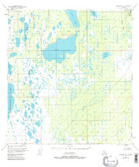
1951 Map of Gulkana B-4
USGS Topo · Published 1983About this map
Ewan Lake dominates the central landscape of this interior Alaskan territory, surrounded by a complex network of wetlands and smaller water bodies such as Birch Lake and Middle Lake. Based on aerial photography from the early 1950s, the terrain shows almost no human development aside from a few isolated Cabins and the prominent corridor of the Trans-Alaska Pipeline running along the eastern edge. This survey, conducted by the U.S. Geological Survey with land lines predetermined by the Bureau of Land Management, captures a wilderness characterized by stagnant water features like Grass Lake and Horseshoe Lake. The absence of roads or established trails at this time emphasizes the isolation of the Copper River Meridian, where the geography was defined almost entirely by its hydrography, including the expansive Crosswind Lake on the western boundary and the drainage of Dog Creek.
Find a feature on this map
18 named features on this map. Tap any name to fly to it.
Don’t see what you’re looking for? This feature index may not catch every label — zoom into the map to look around manually.
Map Details
Editions of this 1951 Gulkana B-4 Map
4 editions found
Other maps of this area

1949 · Gulkana A-3
USGS Topo · 1:63,360

1949 · Gulkana A-5
USGS Topo · 1:63,360

1950 · Gulkana B-3
USGS Topo · 1:63,360

1950 · Gulkana C-3
USGS Topo · 1:63,360

1950 · Gulkana C-4
USGS Topo · 1:63,360

1951 · Gulkana
USGS Topo · 1:250,000

1951 · Gulkana B-5
USGS Topo · 1:63,360

1951 · Gulkana A-4
USGS Topo · 1:63,360

1951 · Gulkana C-5
USGS Topo · 1:63,360

1951 · Gulkana B-4
USGS Topo · 1:63,360