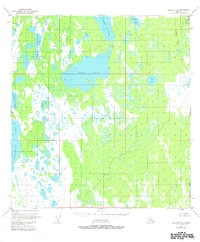
1951 Map of Gulkana B-4
USGS Topo · Published 1983About this map
Ewan Lake dominates this 1951 landscape, surrounded by an intricate network of muskeg and smaller water bodies such as Middle Lake and Birch Lake. Though the topography was mapped from 1950 aerial photographs, later revisions in 1983 trace the path of the Trans-Alaska Pipeline as it cuts north-to-south through the eastern edge of the quadrangle. Human presence is sparse, indicated only by scattered Cabins located near the shorelines of the larger lakes. This terrain is defined by a low-lying, water-heavy character where drainages like Dog Creek connect isolated basins. The map illustrates a transitional period in the Alaskan interior, where the traditional isolation represented by Crosswind Lake began to intersect with the major infrastructure projects of the late twentieth century.
Find a feature on this map
19 named features on this map. Tap any name to fly to it.
Don’t see what you’re looking for? This feature index may not catch every label — zoom into the map to look around manually.
Map Details
Editions of this 1951 Gulkana B-4 Map
4 editions found
Other maps of this area

1949 · Gulkana A-3
USGS Topo · 1:63,360

1949 · Gulkana A-5
USGS Topo · 1:63,360

1950 · Gulkana B-3
USGS Topo · 1:63,360

1950 · Gulkana C-3
USGS Topo · 1:63,360

1950 · Gulkana C-4
USGS Topo · 1:63,360

1951 · Gulkana
USGS Topo · 1:250,000

1951 · Gulkana B-5
USGS Topo · 1:63,360

1951 · Gulkana A-4
USGS Topo · 1:63,360

1951 · Gulkana C-5
USGS Topo · 1:63,360

1951 · Gulkana B-4
USGS Topo · 1:63,360