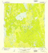
1952 Map of Gulkana B-4
USGS Topo · Published 1953About this map
Ewan Lake dominates the central portion of this 1952 topographic study, revealing a landscape defined by an intricate network of small water bodies and marshy terrain within the Gulkana R drainage. The map captures the remote character of the Third Judicial Division in the early 1950s, where human presence is marked only by a small cluster of Cabins at the northeastern tip of the lake. To the west, the eastern shoreline of Crosswind Lake enters the frame, illustrating the massive scale of the lake systems that supported traditional travel and subsistence in this part of Alaska. This survey, compiled from 1950 aerial photography, provides a detailed record of the hydrography and natural contours before later development or environmental shifts altered these specific basins and drainage patterns.
Find a feature on this map
4 named features on this map. Tap any name to fly to it.
Don’t see what you’re looking for? This feature index may not catch every label — zoom into the map to look around manually.
Map Details
Editions of this 1952 Gulkana B-4 Map
2 editions found
Other maps of this area

1949 · Gulkana A-3
USGS Topo · 1:63,360

1949 · Gulkana A-5
USGS Topo · 1:63,360

1950 · Gulkana B-3
USGS Topo · 1:63,360

1950 · Gulkana C-3
USGS Topo · 1:63,360

1950 · Gulkana C-4
USGS Topo · 1:63,360

1951 · Gulkana
USGS Topo · 1:250,000

1951 · Gulkana B-5
USGS Topo · 1:63,360

1951 · Gulkana A-4
USGS Topo · 1:63,360

1951 · Gulkana C-5
USGS Topo · 1:63,360

1951 · Gulkana B-4
USGS Topo · 1:63,360