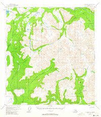
1954 Map of Gulkana D-1
USGS Topo · Published 1963About this map
Mankomen Lake sits in the northwest corner of this interior landscape, marking a rare point of stillness in a region dominated by glacial drainage and river forks. In the mid-1950s, human presence was defined by utility and transit, visible in the Tractor Trail that weaves along Ahtell Creek and the small Cabin structures located near the southern Mine. The drainage network is complex, with the Chistochina River branching into its East Fork and West Fork, while the Slana River cuts across the northeastern reaches. A remote Landing Strip near the lake highlights the era's reliance on bush aviation for reaching these high-elevation valleys. Prominent topographic features like The Dome rise above the confluence of Grubstake Creek and Quartz Creek, where early mineral exploration is evidenced by the presence of a mapped mine.
Find a feature on this map
20 named features on this map. Tap any name to fly to it.
Don’t see what you’re looking for? This feature index may not catch every label — zoom into the map to look around manually.
Map Details
Editions of this 1954 Gulkana D-1 Map
3 editions found
Other maps of this area

1948 · Tanacross A-6
USGS Topo · 1:63,360

1948 · Nabesna C-6
USGS Topo · 1:63,360

1949 · Tanacross
USGS Topo · 1:250,000

1949 · Gulkana C-2
USGS Topo · 1:63,360

1949 · Nabesna D-6
USGS Topo · 1:63,360

1949 · Gulkana C-1
USGS Topo · 1:63,360

1949 · Mt. Hayes A-1
USGS Topo · 1:63,360

1950 · Tanacross
USGS Topo · 1:250,000

1950 · Nabesna
USGS Topo · 1:250,000

1950 · Mount Hayes
USGS Topo · 1:250,000