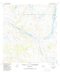
1950 Map of Gulkana D-4
USGS Topo · Published 1991About this map
The Middle Fork Gulkana River winds through this 1950 landscape, a corridor later designated as a Wild and Scenic River. The eastern edge is defined by the expansive Paxson Lake, where the Richardson Highway provides access to the Sportsman Lodge and the small settlement at Hufmans. The topography is dominated by the Alphabet Hills to the southwest and the prominent elevation of Flat Top Mountain near the center. This era represents a time before modern development, where transit through the interior relied heavily on routes like the Winter Trail and the water networks of Swede Lake and Twelvemile Creek. The map records the intersection of high-elevation terrain and the vital river systems that supported early lodge tourism and transportation in this part of the Alaskan interior.
Find a feature on this map
15 named features on this map. Tap any name to fly to it.
Don’t see what you’re looking for? This feature index may not catch every label — zoom into the map to look around manually.
Map Details
Editions of this 1950 Gulkana D-4 Map
4 editions found
Other maps of this area

1949 · Mount Hayes A-4
USGS Topo · 1:63,360

1949 · Gulkana D-3
USGS Topo · 1:63,360

1949 · Mount Hayes A-5
USGS Topo · 1:63,360

1950 · Mount Hayes
USGS Topo · 1:250,000

1950 · Gulkana D-4
USGS Topo · 1:63,360

1950 · Mount Hayes A-3
USGS Topo · 1:63,360

1950 · Gulkana C-3
USGS Topo · 1:63,360

1950 · Gulkana C-4
USGS Topo · 1:63,360

1951 · Gulkana
USGS Topo · 1:250,000

1951 · Mount Hayes
USGS Topo · 1:250,000