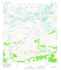
1951 Map of Gulkana D-5
USGS Topo · Published 1967About this map
Glacial waters and braided river systems dominate this interior Alaskan landscape within the Matanuska-Susitna Borough. The northern portion of the map is defined by the expansive Tangle Lakes network, including Upper Tangle Lake, which feed into the headwaters of the Middle Fork Gulkana River. These interconnected water bodies are significant for their role in the region's historical subsistence and travel routes. To the northwest, the Maclaren River cuts through the high-elevation terrain near the South Boundary Fairbanks Meridian. Southward, the topography rises into more prominent ridges, where smaller features like Keg Creek, Moose Creek, and the isolated Twin Lakes are situated. The 1951 field annotation captures a wilderness prior to major infrastructure development, showing only trails through the drainage basins of Dickey Lake and the surrounding tundra.
Find a feature on this map
10 named features on this map. Tap any name to fly to it.
Don’t see what you’re looking for? This feature index may not catch every label — zoom into the map to look around manually.
Map Details
Editions of this 1951 Gulkana D-5 Map
3 editions found
Other maps of this area

1949 · Mount Hayes A-4
USGS Topo · 1:63,360

1949 · Mount Hayes A-5
USGS Topo · 1:63,360

1950 · Mount Hayes
USGS Topo · 1:250,000

1950 · Gulkana D-4
USGS Topo · 1:63,360

1950 · Gulkana C-4
USGS Topo · 1:63,360

1950 · Mount Hayes A-6
USGS Topo · 1:63,360

1951 · Gulkana
USGS Topo · 1:250,000

1951 · Mount Hayes
USGS Topo · 1:250,000

1951 · Gulkana D-6
USGS Topo · 1:63,360

1951 · Gulkana D-5
USGS Topo · 1:63,360