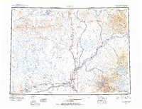
1951 Map of Gulkana
USGS Topo · Published 1951About this map
The Gulkana River and its vast network of glacial tributaries dominate this 1951 compilation of south-central Alaska, tracing a landscape defined by the Richardson Highway and Glenn Highway corridors. The map highlights a series of mid-century lodges and roadhouses that served as vital waypoints for travelers and locals alike, including Atlasta House, Ryans Roadhouse, and Sportsmans Lodge. Strategic infrastructure of the era is evident at the Gulkana Landing Field and the emerging settlement at Glennallen. To the east, the towering peaks of the Wrangell Mountains rise sharply, with Mt Sanford and Mt Drum overlooking the Copper River basin. The presence of numerous small outposts like Sourdough and Poplar Grove along the riverbanks reflects the persistent importance of water and road access in this subarctic interior before later modern developments transformed the region.
Find a feature on this map
109 named features on this map. Tap any name to fly to it.
Don’t see what you’re looking for? This feature index may not catch every label — zoom into the map to look around manually.
Map Details
Editions of this 1951 Gulkana Map
4 editions found

Other maps of this area

1948 · Tanacross A-6
USGS Topo · 1:63,360

1948 · Nabesna C-6
USGS Topo · 1:63,360

1948 · Valdez D-5
USGS Topo · 1:63,360

1948 · Anchorage D-1
USGS Topo · 1:63,360

1949 · Tanacross
USGS Topo · 1:250,000

1949 · Mount Hayes A-4
USGS Topo · 1:63,360

1949 · Gulkana A-3
USGS Topo · 1:63,360

1949 · Gulkana A-5
USGS Topo · 1:63,360

1949 · Talkeetna Mountains A-1
USGS Topo · 1:63,360

1949 · Gulkana C-2
USGS Topo · 1:63,360