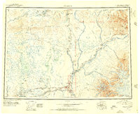
1951 Map of Gulkana
USGS Topo · Published 1956About this map
The Copper River Meridian bisects this interior landscape during a period of post-war northern expansion, centered on the strategic junctions of the Richardson Highway and the Glenn Highway. This era represents the peak of the highway lodge culture in the Copper River Basin, where remote roadhouses like Atlasta House, Sourdough, and Meiers Lake Lodge served as vital waypoints for travelers between the coast and the interior. The settlement at Glennallen PO emerges as a key hub near the confluence of the Gulkana River and the Tazlina River. To the east, the massive volcanic peaks of the Wrangell Mountains, including Mt Sanford and Mt Drum, dominate the skyline above the Sanford River valley. This survey documents the region before modern development, capturing a network of scattered outposts, wilderness airstrips, and traditional river crossings like Gakona and Chistochina.
Find a feature on this map
121 named features on this map. Tap any name to fly to it.
Don’t see what you’re looking for? This feature index may not catch every label — zoom into the map to look around manually.
Map Details
Editions of this 1951 Gulkana Map
4 editions found

Other maps of this area

1948 · Tanacross A-6
USGS Topo · 1:63,360

1948 · Nabesna C-6
USGS Topo · 1:63,360

1948 · Valdez D-5
USGS Topo · 1:63,360

1948 · Anchorage D-1
USGS Topo · 1:63,360

1949 · Tanacross
USGS Topo · 1:250,000

1949 · Mount Hayes A-4
USGS Topo · 1:63,360

1949 · Gulkana A-3
USGS Topo · 1:63,360

1949 · Gulkana A-5
USGS Topo · 1:63,360

1949 · Talkeetna Mountains A-1
USGS Topo · 1:63,360

1949 · Gulkana C-2
USGS Topo · 1:63,360