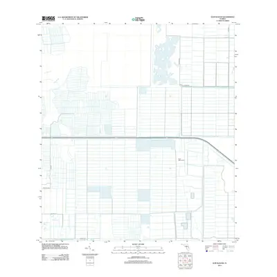
2012 Map of Gum Slough
USGS Topo · Published 2012About this map
Gum Slough and Fort Drum Cr define the western reaches of this landscape in Saint Lucie County, where the natural hydrology of the Florida wetlands meets a highly structured grid of agricultural development. The terrain is characterized by an extensive network of drainage canals and straight-line roads, creating a repeating pattern of rectangular plots that stretch across the quadrangle. Transport and access are facilitated by local routes such as Corrigan Rd and Quay Rd, which cut through the low-lying interior. Central to the area's infrastructure is the Scott 2000 Airport, situated amidst the rural blocks. This 2012 survey illustrates the methodical engineering required to manage water and support land use in this specific part of the Florida peninsula, showing how numbered thoroughfares like Ne 301st Blvd and Ne 304th St organize the territory.
Find a feature on this map
10 named features on this map. Tap any name to fly to it.
Don’t see what you’re looking for? This feature index may not catch every label — zoom into the map to look around manually.
Map Details
Editions of this 2012 Gum Slough Map
This is the sole edition of this map. No revisions or reprints were ever made.
Other maps of this area

1953 · Fort Drum
USGS Topo · 1:24,000

1953 · Fellsmere 4 SE
USGS Topo · 1:24,000

1953 · Fort Drum NE
USGS Topo · 1:24,000

1953 · Fellsmere 4 SW
USGS Topo · 1:24,000

1953 · Fellsmere 4 NW
USGS Topo · 1:24,000

1953 · Taylor Creek NE
USGS Topo · 1:24,000

1953 · Okeechobee 1 NE
USGS Topo · 1:24,000

1953 · Okeechobee 1 NW
USGS Topo · 1:24,000
1953 · Fellsmere 4 NE
USGS Topo · 1:24,000

1956 · Fort Pierce
USGS Topo · 1:250,000