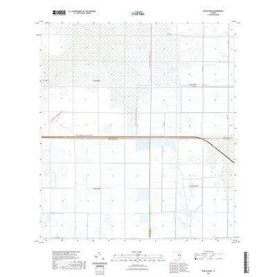
2021 Map of Gum Slough
USGS Topo · Published 2021About this map
Gum Slough and the surrounding wetlands define this modern landscape where the borders of Indian River, Okeechobee, and Saint Lucie counties converge. This 2021 survey illustrates a region dominated by vast drainage networks and conservation efforts, characterized by the Fort Drum Marsh Conservation Area Trl which winds through the western half of the map. Unlike the dense residential development common elsewhere in coastal Florida, this area remains primarily structured by a rigid grid of rural roads and water management features. Isolated landmarks such as Sick Island emerge from the marsh, providing a glimpse into the natural topography that existed before the widespread canal systems of the 20th century. The map tracks the transition from open conservation lands to the organized agricultural and drainage tracts along NE 304th St and 162nd Ave, reflecting contemporary land use in this tri-county interior.
Find a feature on this map
16 named features on this map. Tap any name to fly to it.
Don’t see what you’re looking for? This feature index may not catch every label — zoom into the map to look around manually.
Map Details
Editions of this 2021 Gum Slough Map
This is the sole edition of this map. No revisions or reprints were ever made.
Other maps of this area

1953 · Fort Drum
USGS Topo · 1:24,000

1953 · Fellsmere 4 SE
USGS Topo · 1:24,000

1953 · Fort Drum NE
USGS Topo · 1:24,000

1953 · Fellsmere 4 SW
USGS Topo · 1:24,000

1953 · Fellsmere 4 NW
USGS Topo · 1:24,000

1953 · Taylor Creek NE
USGS Topo · 1:24,000

1953 · Okeechobee 1 NE
USGS Topo · 1:24,000

1953 · Okeechobee 1 NW
USGS Topo · 1:24,000
1953 · Fellsmere 4 NE
USGS Topo · 1:24,000

1956 · Fort Pierce
USGS Topo · 1:250,000