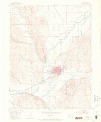
1954 Map of Gunnison
USGS Topo · Published 1965About this map
The Gunnison townsite occupies the center of this mid-century survey, positioned at the confluence of the Gunnison River and Tomichi Creek. The landscape reveals a transition from the agricultural operations at Thornton Ranch and Me Cabe Ranch to the academic grounds of Western State College on the eastern edge of the city. Notable infrastructure includes the Gunnison County Airport and a network of irrigation ditches like the Highline Canal, which support the valley floor. Evidence of former transportation routes is visible in the Old Railroad Grade and several sections of Abandoned RR leading toward the northeast. Beyond the settlement, the terrain rises sharply toward Tenderfoot Mountain, while the Lou Jay Resort sits along the river, indicating the area's role as a regional hub for education, ranching, and outdoor recreation.
Find a feature on this map
38 named features on this map. Tap any name to fly to it.
Don’t see what you’re looking for? This feature index may not catch every label — zoom into the map to look around manually.
Map Details
Editions of this 1954 Gunnison Map
5 editions found
Other maps of this area

1908 · Uncompahgre
USGS Topo · 1:125,000

1911 · Uncompahgre
USGS Topo · 1:125,000

1954 · Iris NW
USGS Topo · 1:24,000

1954 · Iola
USGS Topo · 1:24,000

1954 · Mc Intosh Mountain
USGS Topo · 1:24,000

1954 · Gunnison
USGS Topo · 1:24,000

1956 · Montrose
USGS Topo · 1:250,000

1959 · Montrose
USGS Topo · 1:250,000

1960 · Montrose
USGS Topo · 1:250,000

1962 · Iris
USGS Topo · 1:24,000