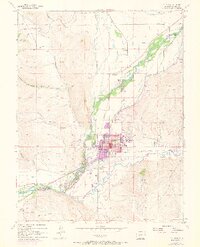
1954 Map of Gunnison
USGS Topo · Published 1973About this map
Gunnison sits at the confluence of the Gunnison River and Tomiichi Creek, serving as a high-altitude hub for education and regional travel in the mid-20th century. The presence of Western State College and the Gunnison County Airport underscores the town's role as a developed center surrounded by ranching and mountain terrain. Evidence of the area's earlier transportation history is visible in the Old Railroad Grade and the Paragon Sch (Aband) near the Gunnison River. Local geography is defined by landmarks like Tenderfoot Mountain to the southeast and drainage systems such as Antelope Creek and Ohio Creek feeding the main river valley. This survey also records various irrigation structures, including a Flume and numerous unnamed Ditch segments, which supported ranching operations like the McCabe Ranch and Thornton Ranch.
Find a feature on this map
42 named features on this map. Tap any name to fly to it.
Don’t see what you’re looking for? This feature index may not catch every label — zoom into the map to look around manually.
Map Details
Editions of this 1954 Gunnison Map
5 editions found
Other maps of this area

1908 · Uncompahgre
USGS Topo · 1:125,000

1911 · Uncompahgre
USGS Topo · 1:125,000

1954 · Iris NW
USGS Topo · 1:24,000

1954 · Iola
USGS Topo · 1:24,000

1954 · Mc Intosh Mountain
USGS Topo · 1:24,000

1954 · Gunnison
USGS Topo · 1:24,000

1956 · Montrose
USGS Topo · 1:250,000

1959 · Montrose
USGS Topo · 1:250,000

1960 · Montrose
USGS Topo · 1:250,000

1962 · Iris
USGS Topo · 1:24,000