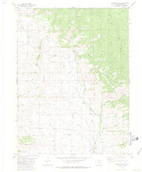
1980 Map of Gunsight Pass
USGS Topo · Published 1981About this map
Gunsight Pass and Antelope Pass anchor this high-country landscape in the Colorado Rockies, where the hydrology of the western slope is defined by intricate water management. The terrain is marked by a series of irrigation and drainage structures, including the Missouri Ditch, Pickering Ditch, and Kirtz Ditch, which divert mountain runoff across the slopes. The drainage system of Troublesome Creek and its many tributaries, such as Buckhorn Creek and Charlie Creek, flows through the central portion of the map, eventually reaching the lower elevations near Little Wolford Mountain.
Find a feature on this map
26 named features on this map. Tap any name to fly to it.
Don’t see what you’re looking for? This feature index may not catch every label — zoom into the map to look around manually.
Map Details
Editions of this 1980 Gunsight Pass Map
3 editions found
Other maps of this area

1954 · Craig
USGS Topo · 1:250,000

1956 · Kremmling
USGS Topo · 1:62,500

1956 · Parkview Mountain
USGS Topo · 1:24,000

1956 · Whiteley Peak
USGS Topo · 1:24,000

1956 · Hyannis Peak
USGS Topo · 1:24,000

1956 · Hyannis Peak
USGS Topo · 1:62,500

1956 · Rand
USGS Topo · 1:62,500

1957 · Craig
USGS Topo · 1:250,000

1957 · Hot Sulphur Springs
USGS Topo · 1:62,500

1958 · Craig
USGS Topo · 1:250,000