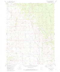
1980 Map of Gunsight Pass
USGS Topo · Published 1986About this map
Gunsight Pass and Antelope Pass provide the primary geographic relief in this high-altitude portion of Grand County, where ranching and water management define the landscape. The intricate network of irrigation channels, including Pickering Ditch, Missouri Ditch, and Kirtz Ditch, illustrates a long-standing reliance on diverted alpine runoff for local agriculture and livestock. In the eastern reaches, the Arapaho National Forest marks a transition into more heavily timbered terrain near Monument Creek. The map documents several prospect sites near Little Wolford Mountain and Hay Gulch, reflecting historical mineral exploration in the region. Transportation is largely limited to a pack trail system and a few unimproved roads, highlighting the area's secluded character during the late 1970s.
Find a feature on this map
30 named features on this map. Tap any name to fly to it.
Don’t see what you’re looking for? This feature index may not catch every label — zoom into the map to look around manually.
Map Details
Editions of this 1980 Gunsight Pass Map
3 editions found
Other maps of this area

1954 · Craig
USGS Topo · 1:250,000

1956 · Kremmling
USGS Topo · 1:62,500

1956 · Parkview Mountain
USGS Topo · 1:24,000

1956 · Whiteley Peak
USGS Topo · 1:24,000

1956 · Hyannis Peak
USGS Topo · 1:24,000

1956 · Hyannis Peak
USGS Topo · 1:62,500

1956 · Rand
USGS Topo · 1:62,500

1957 · Craig
USGS Topo · 1:250,000

1957 · Hot Sulphur Springs
USGS Topo · 1:62,500

1958 · Craig
USGS Topo · 1:250,000