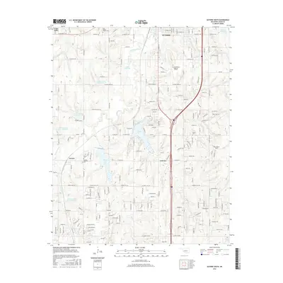
2016 Map of Guthrie South
USGS Topo · Published 2016About this map
The northern edge of Guthrie transitions into a landscape defined by water management and mid-continent transportation. This 2016 survey documents a network of flood control structures along Cottonwood Creek, including Cottonwood Creek Site 3 Reservoir and Cottonwood Creek Site 4 Reservoir. These reservoirs sit alongside historical sites such as Seward, where local genealogy is preserved at the Seward Cemetery and Seward Memorial Cemetery. To the east, the Guthrie-Edmond Regional Airport and Ellis/Harvey Airport reflect the area's modern aviation role, while older landmarks like the Saint Joseph's Academy Cemetery and Green Gable anchor the map in the region's earlier development. Large water bodies such as Guthrie Lake and Liberty Lake provide distinct geographic anchors in this part of Logan County.
Find a feature on this map
92 named features on this map. Tap any name to fly to it.
Don’t see what you’re looking for? This feature index may not catch every label — zoom into the map to look around manually.
Map Details
Editions of this 2016 Guthrie South Map
This is the sole edition of this map. No revisions or reprints were ever made.
Other maps of this area

1892 · Guthrie
USGS Topo · 1:62,500

1892 · Edmond
USGS Topo · 1:62,500

1892 · Kingfisher
USGS Topo · 1:125,000

1895 · Kingfisher
USGS Topo · 1:125,000

1935 · Edmond
USGS Topo · 1:48,000

1940 · Edmond
USGS Topo · 1:62,500

1954 · Oklahoma City
USGS Topo · 1:250,000

1957 · Oklahoma City
USGS Topo · 1:250,000

1963 · Oklahoma City
USGS Topo · 1:250,000
1966 · Arcadia
USGS Topo · 1:24,000