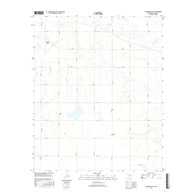
2016 Map of Hackberry Flat
USGS Topo · Published 2016About this map
Hackberry Flat dominates this portion of Tillman County, reflecting the unique wetland and prairie restoration landscape southeast of Frederick. The area is defined by a rigorous grid of section-line roads, such as n2240 RD and e1870 RD, which partition the agricultural and conservation lands. For those researching local history or genealogy, the map identifies significant sites like Hackberry Cem and Dunkard Cem, which serve as quiet landmarks of the region's early settlement era. In the northern reaches, the Frederick Regional Airport provides a modern contrast to the natural hydrology of Salt Cr and Little Deep Red Cr. The presence of the 141001 Reservoir further highlights the managed water systems crucial to this Oklahoma terrain.
Find a feature on this map
23 named features on this map. Tap any name to fly to it.
Don’t see what you’re looking for? This feature index may not catch every label — zoom into the map to look around manually.
Map Details
Editions of this 2016 Hackberry Flat Map
This is the sole edition of this map. No revisions or reprints were ever made.
Other maps of this area

1955 · Lawton
USGS Topo · 1:250,000

1958 · Davidson
USGS Topo · 1:62,500

1958 · Frederick
USGS Topo · 1:62,500

1958 · Electra
USGS Topo · 1:62,500

1974 · Hollister NW
USGS Topo · 1:24,000

1974 · Hackberry Flat
USGS Topo · 1:24,000
1974 · Hollister
USGS Topo · 1:24,000
1974 · Hollister NE
USGS Topo · 1:24,000

1975 · Frederick NE
USGS Topo · 1:24,000

1975 · Frederick SE
USGS Topo · 1:24,000