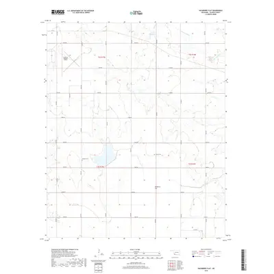
2018 Map of Hackberry Flat
USGS Topo · Published 2018About this map
Hackberry Flat occupies the central depression of this Tillman County landscape, where the flat terrain is defined by a strictly surveyed grid of county roads including E1880 Rd and N2260 Rd. The map reveals the local genealogical significance of Hackberry Cem and Dunkard Cem, which stand as markers of early community identity in this agricultural region. Water features like Salt Cr and Little Deep Red Cr provide drainage for the surrounding plains, while the 141001 Reservoir serves as a modern water management point. In the northwest corner, the Frederick Regional Airport represents the region's transportation infrastructure, contrasting with the rural character of the southern townships.
Find a feature on this map
28 named features on this map. Tap any name to fly to it.
Don’t see what you’re looking for? This feature index may not catch every label — zoom into the map to look around manually.
Map Details
Editions of this 2018 Hackberry Flat Map
This is the sole edition of this map. No revisions or reprints were ever made.
Other maps of this area

1955 · Lawton
USGS Topo · 1:250,000

1958 · Davidson
USGS Topo · 1:62,500

1958 · Frederick
USGS Topo · 1:62,500

1958 · Electra
USGS Topo · 1:62,500

1974 · Hollister NW
USGS Topo · 1:24,000

1974 · Hackberry Flat
USGS Topo · 1:24,000
1974 · Hollister
USGS Topo · 1:24,000
1974 · Hollister NE
USGS Topo · 1:24,000

1975 · Frederick NE
USGS Topo · 1:24,000

1975 · Frederick SE
USGS Topo · 1:24,000