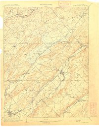
1905 Map of Hackettstown
USGS Topo · Published 1910About this map
The Morris Canal snakes through the Musconetcong Valley in this early 20th-century survey, revealing a landscape defined by the convergence of heavy industry and transport. At Hackettstown, the local economy is anchored by the crossing of the Delaware Lackawanna and Western Railroad and the canal, while to the west, the Oxford Tunnel pierces the terrain near the Pohatcong Creek. The map documents a transition in regional commerce, as older settlements like Waterloo and Saxton Falls sit alongside the expanding rail networks of the Lehigh and Hudson River Railroad and the New York Susquehanna and Western Railroad.
Find a feature on this map
90 named features on this map. Tap any name to fly to it.
Don’t see what you’re looking for? This feature index may not catch every label — zoom into the map to look around manually.
Map Details
Editions of this 1905 Hackettstown Map
5 editions found

Other maps of this area

1888 · Franklin
USGS Topo · 1:62,500

1888 · Hackettstown
USGS Topo · 1:62,500

1888 · Lake Hopatcong
USGS Topo · 1:62,500

1890 · Easton
USGS Topo · 1:62,500

1890 · High Bridge
USGS Topo · 1:62,500

1891 · Somerville
USGS Topo · 1:62,500

1891 · Easton
USGS Topo · 1:62,500

1891 · Wallpack
USGS Topo · 1:62,500

1891 · Delaware Water Gap
USGS Topo · 1:62,500

1893 · Delaware Water Gap
USGS Topo · 1:62,500