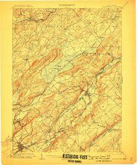
1905 Map of Hackettstown
USGS Topo · Published 1910About this map
Hackettstown serves as a central hub in this early twentieth-century survey, situated where the Musconetcong River and the Morris Canal parallel the route of the Delaware Lackawanna and Western Railroad. The landscape is defined by the prominent ridge of Schooley Mountain and the distinct geologic feature of the Rockport Moraine. To the northwest, the Pequest River winds through a complex valley system flanked by Jenny Jump Mountain and Mt. Mohepinoke. The map illustrates a dense industrial and transport network, featuring the Oxford Tunnel and a series of islands within the Great Meadows area, such as Whiteoak Island and Posts Island. Small nineteenth-century hamlets like Swayze Mills, Vienna, and Beattyestown are meticulously documented alongside the rail stops at Allamuchy Sta. and Tranquility. This record preserves the sophisticated intersection of canal, rail, and water power that drove the region's early growth.
Find a feature on this map
102 named features on this map. Tap any name to fly to it.
Don’t see what you’re looking for? This feature index may not catch every label — zoom into the map to look around manually.
Map Details
Editions of this 1905 Hackettstown Map
5 editions found

Other maps of this area

1888 · Franklin
USGS Topo · 1:62,500

1888 · Hackettstown
USGS Topo · 1:62,500

1888 · Lake Hopatcong
USGS Topo · 1:62,500

1890 · Easton
USGS Topo · 1:62,500

1890 · High Bridge
USGS Topo · 1:62,500

1891 · Somerville
USGS Topo · 1:62,500

1891 · Easton
USGS Topo · 1:62,500

1891 · Wallpack
USGS Topo · 1:62,500

1891 · Delaware Water Gap
USGS Topo · 1:62,500

1893 · Delaware Water Gap
USGS Topo · 1:62,500