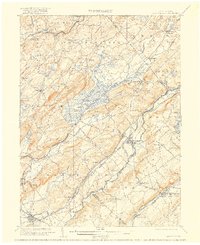
1905 Map of Hackettstown
USGS Topo · Published 1916About this map
Hackettstown serves as a primary hub for this early twentieth-century portrait of northwest New Jersey, where the Musconetcong River and Pequest River valleys define the industrial and agricultural corridors of the region. The landscape is heavily marked by the intersection of major rail networks and early milling operations, such as Swayze Mills and the transit hub at Waterloo. Notable engineering of the era is evident in the Oxford Tunnel and the multiple lines of the Delaware Lackawanna and Western RR that traverse the ridges and basins. Smaller hamlets like Johnsonburg, Tranquility, and Blairstown are connected by a web of rural roads, while the presence of Saxton Falls and numerous islands like Roes Island highlights the importance of water power and geography in the local economy. This survey captures the county lines of Warren, Morris, and Hunterdon as they converge amidst prominent terrain features like Mt. Mohepinoke.
Find a feature on this map
90 named features on this map. Tap any name to fly to it.
Don’t see what you’re looking for? This feature index may not catch every label — zoom into the map to look around manually.
Map Details
Editions of this 1905 Hackettstown Map
5 editions found

Other maps of this area

1888 · Franklin
USGS Topo · 1:62,500

1888 · Hackettstown
USGS Topo · 1:62,500

1888 · Lake Hopatcong
USGS Topo · 1:62,500

1890 · Easton
USGS Topo · 1:62,500

1890 · High Bridge
USGS Topo · 1:62,500

1891 · Somerville
USGS Topo · 1:62,500

1891 · Easton
USGS Topo · 1:62,500

1891 · Wallpack
USGS Topo · 1:62,500

1891 · Delaware Water Gap
USGS Topo · 1:62,500

1893 · Delaware Water Gap
USGS Topo · 1:62,500