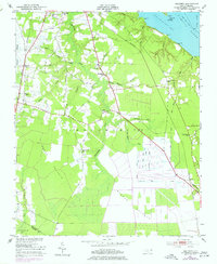
1951 Map of Hackney
USGS Topo · Published 1977About this map
The Norfolk Southern railroad cuts a diagonal path through the lowlands of Chocowinity in the mid-20th century, connecting small rural outposts like Hackney and Rover. This landscape is defined by the transition from the Pamlico River and Chocowinity Bay into the dense, saturated reaches of Reedy Pocosin and Blount Pocosin. The map documents a scattered agrarian community supported by numerous local institutions, including Union Chapel, St James Ch, and the Edwards Cem.
Find a feature on this map
36 named features on this map. Tap any name to fly to it.
Don’t see what you’re looking for? This feature index may not catch every label — zoom into the map to look around manually.
Map Details
Editions of this 1951 Hackney Map
3 editions found
Other maps of this area

1902 · Vanceboro
USGS Topo · 1:62,500

1903 · Chocowinity
USGS Topo · 1:62,500

1904 · Vanceboro
USGS Topo · 1:62,500

1905 · Chocowinity
USGS Topo · 1:62,500

1905 · Vanceboro
USGS Topo · 1:62,500

1943 · Plymouth
USGS Topo · 1:125,000

1950 · Edward
USGS Topo · 1:24,000

1951 · Bunyan
USGS Topo · 1:24,000

1951 · Hackney
USGS Topo · 1:24,000

1951 · Washington
USGS Topo · 1:24,000