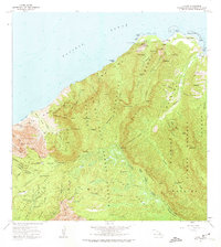
1965 Map of Haena
USGS Topo · Published 1974About this map
Haena and the northern coast of Kauai are defined here by a sharp transition from the Pacific Ocean to the towering ridges of the Na Pali-Kona Forest Reserve. This 1965 field-checked survey highlights a landscape where ancient Hawaiian cultural sites like Ka Ulu a Paoa Heiau and the Lohiau House (Site) sit alongside geological wonders such as Waikapalae Wet Cave and Haena Dry Cave. The mapping detail focuses heavily on the drainage systems of the Wainiha River and Hanakapiai Stream, showing the infrastructure that supported the local valley economy, including a Powerhouse and Penstock near Kealawela.
Find a feature on this map
119 named features on this map. Tap any name to fly to it.
Don’t see what you’re looking for? This feature index may not catch every label — zoom into the map to look around manually.
Map Details
Editions of this 1965 Haena Map
2 editions found
Other maps of this area

1954 · Kauai
USGS Topo · 1:250,000

1963 · Hanalei
USGS Topo · 1:24,000

1965 · Waimea Canyon
USGS Topo · 1:24,000

1965 · Haena
USGS Topo · 1:24,000

1965 · Makaha Point
USGS Topo · 1:24,000

1965 · Waialeale
USGS Topo · 1:24,000

1967 · Kauai
USGS Topo · 1:250,000

1970 · Kauai
USGS Topo · 1:250,000
1983 · Hanalei
USGS Topo · 1:24,000
1983 · Haena
USGS Topo · 1:24,000